Spenden
Topografische Karte Blois
Klicken Sie auf die Karte, um die Höhe anzuzeigen.
Spenden
Blois
La ville basse est posée sur les alluvions récentes du lit majeur entre fleuve et coteau (altitude moyenne : 70 m). La ville haute est ancrée dans les coteaux calcaires de la Loire et de l’Arrou ou posée sur le plateau de la Petite Beauce (100 à 110 m) constitué par la même roche. La forêt est située sur une très mince épaisseur de limon des plateaux qui recouvre l’argile à silex, couche imperméable.
Spenden
Über diese Karte
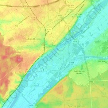
Name: Topografische Karte Blois, Höhe, Relief.
Durchschnittliche Höhe: 95 m
Minimale Höhe: 63 m
Maximale Höhe: 142 m
Spenden
Andere topografische Karten
Klicken Sie auf eine Karte, um ihre Topografie, ihre Höhe und ihr Relief anzuzeigen.
Château de Ronsard
France > Centre-Val de Loire > Loir-et-Cher > Vallée-de-Ronsard > Couture-sur-Loir > Le Grand Cimetière
Durchschnittliche Höhe: 84 m
Spenden
Le Port
France > Centre-Val de Loire > Loir-et-Cher > Saint-Georges-sur-Cher
Durchschnittliche Höhe: 88 m
Les Forges
France > Centre-Val de Loire > Loir-et-Cher > Candé-sur-Beuvron
Durchschnittliche Höhe: 82 m
Le Grand Cimetière
France > Centre-Val de Loire > Loir-et-Cher > Huisseau-en-Beauce
Durchschnittliche Höhe: 120 m
Spenden
Le Tarrage
France > Centre-Val de Loire > Loir-et-Cher > La Ferté-Saint-Cyr
Durchschnittliche Höhe: 103 m
Le Bourg
France > Centre-Val de Loire > Loir-et-Cher > Monthou-sur-Bièvre
Durchschnittliche Höhe: 89 m
Abbaye de Cornilly
France > Centre-Val de Loire > Loir-et-Cher > Le Controis-en-Sologne
Durchschnittliche Höhe: 111 m
Spenden
Le Bois de la Guille
France > Centre-Val de Loire > Loir-et-Cher > Morée
Durchschnittliche Höhe: 121 m
Nozieux
France > Centre-Val de Loire > Loir-et-Cher > Saint-Claude-de-Diray
Durchschnittliche Höhe: 82 m
Spenden
Le Carroir
France > Centre-Val de Loire > Loir-et-Cher > Chaumont-sur-Loire
Durchschnittliche Höhe: 84 m
Le Parc
France > Centre-Val de Loire > Loir-et-Cher > Soings-en-Sologne > Les Prés Montoux
Durchschnittliche Höhe: 110 m
La Mahaudière
France > Centre-Val de Loire > Loir-et-Cher > Mareuil-sur-Cher
Durchschnittliche Höhe: 145 m
Spenden
Les Terres Noires
France > Centre-Val de Loire > Loir-et-Cher > Saint-Hilaire-la-Gravelle
Durchschnittliche Höhe: 123 m
Le Controis en Sologne
France > Centre-Val de Loire > Loir-et-Cher > Le Controis-en-Sologne
Durchschnittliche Höhe: 104 m
Le Gatinais
France > Centre-Val de Loire > Loir-et-Cher > Souvigny-en-Sologne
Durchschnittliche Höhe: 146 m
Spenden
Le Marchais Griffon
France > Centre-Val de Loire > Loir-et-Cher > La Ferté-Saint-Cyr
Durchschnittliche Höhe: 95 m
Château de Vendôme
France > Centre-Val de Loire > Loir-et-Cher > Vendôme > Faubourg Saint-Lubin
Durchschnittliche Höhe: 105 m
Les Boussets
France > Centre-Val de Loire > Loir-et-Cher > Artins > Le Port d'Artins
Durchschnittliche Höhe: 78 m
Vrigny
France > Centre-Val de Loire > Loir-et-Cher > Saint-Georges-sur-Cher
Durchschnittliche Höhe: 85 m
Spenden
Le Petit Chambord
France > Centre-Val de Loire > Loir-et-Cher > Romorantin-Lanthenay
Durchschnittliche Höhe: 102 m
Spenden
Rochambeau
France > Centre-Val de Loire > Loir-et-Cher > Thoré-la-Rochette
Durchschnittliche Höhe: 94 m
Les Verts Manteaux
France > Centre-Val de Loire > Loir-et-Cher > Montrichard Val de Cher
Durchschnittliche Höhe: 95 m
Spenden
La Poterie
France > Centre-Val de Loire > Loir-et-Cher > Saint-Georges-sur-Cher
Durchschnittliche Höhe: 90 m
Les Fresnes
France > Centre-Val de Loire > Loir-et-Cher > Saint-Amand-Longpré
Durchschnittliche Höhe: 123 m
La Gare
France > Centre-Val de Loire > Loir-et-Cher > Le Gault-du-Perche
Durchschnittliche Höhe: 190 m
Spenden
Le Mesnil
France > Centre-Val de Loire > Loir-et-Cher > Saint-Georges-sur-Cher
Durchschnittliche Höhe: 87 m
Spenden
Le Petit Villiers
France > Centre-Val de Loire > Loir-et-Cher > Neung-sur-Beuvron
Durchschnittliche Höhe: 99 m
Spenden
Les Sables d'Olonne
France > Centre-Val de Loire > Loir-et-Cher > Mondoubleau
Durchschnittliche Höhe: 147 m
Château du Moulin
France > Centre-Val de Loire > Loir-et-Cher > Gy-en-Sologne
Durchschnittliche Höhe: 97 m
Spenden
Le Bourg
France > Centre-Val de Loire > Loir-et-Cher > Villiers-sur-Loir
Durchschnittliche Höhe: 106 m
Bellevue
France > Centre-Val de Loire > Loir-et-Cher > Vallée-de-Ronsard > Couture-sur-Loir
Durchschnittliche Höhe: 76 m
Les Crocs
France > Centre-Val de Loire > Loir-et-Cher > Saint-Hilaire-la-Gravelle
Durchschnittliche Höhe: 129 m
La Roche
France > Centre-Val de Loire > Loir-et-Cher > Savigny-sur-Braye
Durchschnittliche Höhe: 113 m
Spenden
Le Stade
France > Centre-Val de Loire > Loir-et-Cher > Salbris > Le Colombier
Durchschnittliche Höhe: 108 m
Spenden
Les Bois de la Charbonnière
France > Centre-Val de Loire > Loir-et-Cher > Crouy-sur-Cosson
Durchschnittliche Höhe: 103 m
La Guimperie
France > Centre-Val de Loire > Loir-et-Cher > Villedieu-le-Château
Durchschnittliche Höhe: 94 m
Clos Bonjean
France > Centre-Val de Loire > Loir-et-Cher > Prunay-Cassereau
Durchschnittliche Höhe: 137 m
Spenden
Les Fontenelles
France > Centre-Val de Loire > Loir-et-Cher > Saint-Julien-de-Chédon
Durchschnittliche Höhe: 111 m
Les Chevinières
France > Centre-Val de Loire > Loir-et-Cher > Pruniers-en-Sologne
Durchschnittliche Höhe: 99 m
Spenden
Les Mesles
France > Centre-Val de Loire > Loir-et-Cher > Thoré-la-Rochette > Le Fougeret
Durchschnittliche Höhe: 103 m
Le Pont de Sauldre
France > Centre-Val de Loire > Loir-et-Cher > Châtillon-sur-Cher
Durchschnittliche Höhe: 86 m
Spenden
La Bataille
France > Centre-Val de Loire > Loir-et-Cher > Savigny-sur-Braye
Durchschnittliche Höhe: 117 m
La Mezières
France > Centre-Val de Loire > Loir-et-Cher > Crouy-sur-Cosson
Durchschnittliche Höhe: 92 m
Boulaire
France > Centre-Val de Loire > Loir-et-Cher > Pierrefitte-sur-Sauldre
Durchschnittliche Höhe: 129 m
Spenden
Boissière
France > Centre-Val de Loire > Loir-et-Cher > Saint-Sulpice-de-Pommeray
Durchschnittliche Höhe: 110 m
Château de Chambord
France > Centre-Val de Loire > Loir-et-Cher > Chambord > Le Bourg
Durchschnittliche Höhe: 86 m
Spenden
Réserve naturelle des vallées de la Grand-Pierre et de Vitain
France > Centre-Val de Loire > Loir-et-Cher > Averdon > Villiers
Durchschnittliche Höhe: 106 m
La Plage
France > Centre-Val de Loire > Loir-et-Cher > Faverolles-sur-Cher
Durchschnittliche Höhe: 93 m
Spenden
Le Bourg-Nord
France > Centre-Val de Loire > Loir-et-Cher > Châtillon-sur-Cher
Durchschnittliche Höhe: 91 m
Spenden
La CHapelle
France > Centre-Val de Loire > Loir-et-Cher > Chaumont-sur-Loire
Durchschnittliche Höhe: 86 m
La République
France > Centre-Val de Loire > Loir-et-Cher > Montrieux-en-Sologne
Durchschnittliche Höhe: 101 m
Île de Muides
France > Centre-Val de Loire > Loir-et-Cher > Muides-sur-Loire
Durchschnittliche Höhe: 84 m
Les Pontonnières
France > Centre-Val de Loire > Loir-et-Cher > Valencisse
Durchschnittliche Höhe: 117 m
Spenden
Les Malvoisies
France > Centre-Val de Loire > Loir-et-Cher > Fontaine-les-Coteaux
Durchschnittliche Höhe: 129 m
Le Bouillon
France > Centre-Val de Loire > Loir-et-Cher > Saint-Hilaire-la-Gravelle
Durchschnittliche Höhe: 125 m
Spenden
Petit Beaumont
France > Centre-Val de Loire > Loir-et-Cher > Cour-Cheverny
Durchschnittliche Höhe: 88 m
Bourg de Lassay
France > Centre-Val de Loire > Loir-et-Cher > Lassay-sur-Croisne
Durchschnittliche Höhe: 100 m
Spenden
