
Vielen Dank für die Unterstützung dieser Website ❤️
Spenden
Spenden
Topografische Karte Puyo
Klicken Sie auf die Karte, um die Höhe anzuzeigen.
Vielen Dank für die Unterstützung dieser Website ❤️
Spenden
Spenden
Über diese Karte
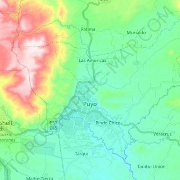
Name: Topografische Karte Puyo, Höhe, Relief.
Ort: Puyo, Pastaza, Ecuador (-1.52890 -78.05687 -1.42083 -77.91932)
Durchschnittliche Höhe: 1.022 m
Minimale Höhe: 880 m
Maximale Höhe: 1.408 m
Vielen Dank für die Unterstützung dieser Website ❤️
Spenden
Spenden