
Topografische Karte Karatschi
Interaktive Karte
Klicken Sie auf die Karte, um die Höhe anzuzeigen.
Karatschi
Die Masjid-e-Tooba ist eine weitere Attraktion. Die 1969 aus weißem Marmor errichtete Moschee hat einen Durchmesser von 72 Metern und besitzt ein Minarett mit einer Höhe von 70 Metern. Das Dach ruht auf einer niedrigen Außenwand ohne zentrale Stützpfeiler. Die zentrale Gebetshalle hat eine Kapazität von 5.000 Personen.
Über diese Karte
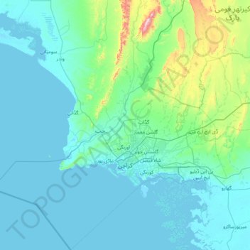
Name: Topografische Karte Karatschi, Höhe, Relief.
Ort: Karatschi, Sindh, Pakistan (24.42735 66.28623 25.67680 67.55541)
Durchschnittliche Höhe: 89 m
Minimale Höhe: -2 m
Maximale Höhe: 1.065 m
Andere topografische Karten
Klicken Sie auf eine Karte, um ihre Topografie, ihre Höhe und ihr Relief anzuzeigen.