Topografische Karte Toronto
Interaktive Karte
Klicken Sie auf die Karte, um die Höhe anzuzeigen.
Über diese Karte
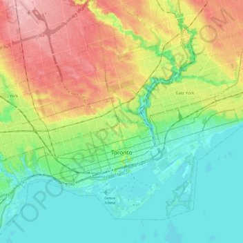
Name: Topografische Karte Toronto, Höhe, Relief.
Ort: Toronto, Golden Horseshoe, Ontario, Kanada (43.61038 -79.49282 43.73602 -79.27851)
Durchschnittliche Höhe: 116 m
Minimale Höhe: 68 m
Maximale Höhe: 201 m
Während der letzten Eiszeit lag der niedrigere Teil des Stadtgebietes unter dem Glacial Lake Iroquois, einem Eisstausee. Geländeabbrüche, die auf diese Zeit zurückgehen, sind von der östlich der Stadtmitte verlaufenden Victoria Park Avenue an der Mündung des Highland Creek zu erkennen. Die Scarborough Bluffs sind schroffe Felsklippen bis zu einer Höhe von 65 Metern auf einer Länge von 14 Kilometern entlang der Uferlinie des Ontariosees. Toronto hat keine nennenswerten Erhebungen. Der niedrigste Punkt liegt am Ufer des Ontariosees auf 75 Metern über dem Meeresspiegel, der höchste auf 270 Metern nahe der York University im Norden der Stadt.
Andere topografische Karten
Klicken Sie auf eine Karte, um ihre Topografie, ihre Höhe und ihr Relief anzuzeigen.
Shore Island
Kanada > Ontario > Kenora District > Unorganized Kenora District
Shore Island, Unorganized Kenora District, Kenora District, Northwestern Ontario, Ontario, Kanada
Durchschnittliche Höhe: 345 m
Unorganized West Timiskaming
Kanada > Ontario > Timiskaming District
Unorganized West Timiskaming, Timiskaming District, Northeastern Ontario, Ontario, Kanada
Durchschnittliche Höhe: 341 m
Tweed
Kanada > Ontario > Hastings County > Tweed
Tweed, Hastings County, Central Ontario, Ontario, Kanada
Durchschnittliche Höhe: 231 m
Manotick
Kanada > Ontario > Ottawa > Rideau Township
Manotick, Rideau-Goulbourn, Rideau Township, Ottawa, Eastern Ontario, Ontario, Kanada
Durchschnittliche Höhe: 94 m
Grand River
Grand River, Wellington County, Southwestern Ontario, Ontario, N0B 2V0, Kanada
Durchschnittliche Höhe: 300 m
Ontariosee
Kanada > Ontario > Quinte West
Ontariosee, Quinte West, Central Ontario, Ontario, Kanada
Durchschnittliche Höhe: 215 m
Red Rock River
Kanada > Ontario > Unorganized North Algoma
Red Rock River, Unorganized North Algoma, Algoma District, Ontario, Kanada
Durchschnittliche Höhe: 395 m
Stormont, Dundas and Glengarry Counties
Stormont, Dundas and Glengarry Counties, Eastern Ontario, Ontario, Kanada
Durchschnittliche Höhe: 86 m
DeCelles Island
Kanada > Ontario > The North Shore
DeCelles Island, The North Shore, Algoma District, Ontario, Kanada
Durchschnittliche Höhe: 224 m
Winnipeg River
Kanada > Ontario > Unorganized Kenora District
Winnipeg River, Unorganized Kenora District, Kenora District, Ontario, Kanada
Durchschnittliche Höhe: 323 m
Timiskaming District
Timiskaming District, Northeastern Ontario, Ontario, Kanada
Durchschnittliche Höhe: 331 m
Michaels Island
Kanada > Ontario > South Frontenac Township
Michaels Island, South Frontenac Township, Frontenac County, Ontario, Kanada
Durchschnittliche Höhe: 169 m
Manitoulin District
Manitoulin District, Ontario, Kanada
Durchschnittliche Höhe: 211 m
Bruce County
Bruce County, Southwestern Ontario, Ontario, Kanada
Durchschnittliche Höhe: 232 m
Nipigonsee
Kanada > Ontario > Unorganized Thunder Bay District
Nipigonsee, Unorganized Thunder Bay District, Thunder Bay District, Northwestern Ontario, Ontario, Kanada
Durchschnittliche Höhe: 307 m
Young Island
Kanada > Ontario > The Archipelago
Young Island, The Archipelago, Parry Sound District, Ontario, Kanada
Durchschnittliche Höhe: 197 m
Dufferin Island
Kanada > Ontario > Northeastern Manitoulin and the Islands
Dufferin Island, Northeastern Manitoulin and the Islands, Manitoulin District, Ontario, Kanada
Durchschnittliche Höhe: 203 m
Rivière la Martre
Kanada > Ontario > Unorganized Kenora District
Rivière la Martre, 325, Unorganized Kenora District, Kenora District, Ontario, Kanada
Durchschnittliche Höhe: 427 m
Nipigon River
Nipigon River, Thunder Bay District, Northwestern Ontario, Ontario, P0T 2P0, Kanada
Durchschnittliche Höhe: 297 m
Victoria Island
Victoria Island, (Old) Ottawa, Ottawa, Ontario, K1R 1C5, Kanada
Durchschnittliche Höhe: 126 m
Flour Mill
Kanada > Ontario > Greater Sudbury
Flour Mill, Greater Sudbury, Ontario, P3C 5J7, Kanada
Durchschnittliche Höhe: 276 m
Thunder Bay District
Thunder Bay District, Ontario, Kanada
Durchschnittliche Höhe: 313 m
Belleville
Kanada > Ontario > Belleville
Belleville, Ontario, K8N 2Y8, Kanada
Durchschnittliche Höhe: 107 m