
Vielen Dank für die Unterstützung dieser Website ❤️
Spenden
Spenden
Topografische Karte Papeete
Klicken Sie auf die Karte, um die Höhe anzuzeigen.
Vielen Dank für die Unterstützung dieser Website ❤️
Spenden
Spenden
Über diese Karte
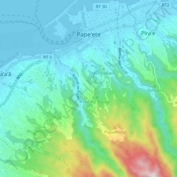
Name: Topografische Karte Papeete, Höhe, Relief.
Durchschnittliche Höhe: 224 m
Minimale Höhe: -2 m
Maximale Höhe: 1.133 m
Vielen Dank für die Unterstützung dieser Website ❤️
Spenden
Spenden
Andere topografische Karten
Klicken Sie auf eine Karte, um ihre Topografie, ihre Höhe und ihr Relief anzuzeigen.
Makatea
Frankreich > Französisch-Polynesien > Rangiroa
Die Insel liegt südlich der Palliser-Inseln, ihre Fläche beträgt 24 km². Höchste Erhebung ist der Mont Puutiare mit 110 Metern Höhe im Norden der Insel. Der Mont Aetia im Westen, die zweithöchste Erhebung, erreicht 90 Meter.
Durchschnittliche Höhe: 27 m