
Topografische Karte Sankt Martin
Interaktive Karte
Klicken Sie auf die Karte, um die Höhe anzuzeigen.
Sankt Martin
Die Stadt befindet sich im nördlichen Teil des Turzbeckens (slowakisch Turčianska kotlina) am Fluss Turiec, kurz vor dessen Mündung in die Waag. Westlich und nördlich der Stadt erhebt sich die Kleine Fatra, genauer deren Teil Lúčanská Fatra, weiter östlich ist die Große Fatra zu sehen. Das Gemeindegebiet ist 67,736 km² groß und umfasst einen Teil der hügellandartigen Landschaft am Turzbecken und den Ostteil der Lúčanská Fatra unterhalb der Berge Veľká Lúka (1476 m n.m.) und Krížava (1457 m n.m.). Das Stadtzentrum liegt auf einer Höhe von 395 m n.m. und ist 30 Kilometer von Žilina, 60 Kilometer von Banská Bystrica sowie jeweils etwa 230 Kilometer von Bratislava und Košice entfernt (Straßenentfernungen).
Über diese Karte
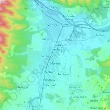
Name: Topografische Karte Sankt Martin, Höhe, Relief.
Durchschnittliche Höhe: 484 m
Minimale Höhe: 371 m
Maximale Höhe: 1.173 m