
Topografische Karte Cuneo
Interaktive Karte
Klicken Sie auf die Karte, um die Höhe anzuzeigen.
Über diese Karte
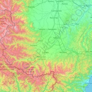
Name: Topografische Karte Cuneo, Höhe, Relief.
Ort: Cuneo, Piemont, Italien (44.05972 6.85451 44.85661 8.26921)
Durchschnittliche Höhe: 1.021 m
Minimale Höhe: 0 m
Maximale Höhe: 3.790 m
Andere topografische Karten
Klicken Sie auf eine Karte, um ihre Topografie, ihre Höhe und ihr Relief anzuzeigen.
Alpe Cheggio
Italien > Piemont > Verbano-Cusio-Ossola > Antrona Schieranco
Durchschnittliche Höhe: 1.830 m
Fontana dell' Albi
Italien > Piemont > Verbano-Cusio-Ossola > Pieve Vergonte
Durchschnittliche Höhe: 1.344 m
Monte Jafferau
Italien > Piemont > Turin > Bardonecchia
Der Monte Jafferau ist ein 2805 m s.l.m. hoher Berg in den Cottischen Alpen in Italien im Grenzgebiet zu Frankreich. Er erhebt sich östlich der Stadt Bardonecchia linksseitig der Dora di Bardonecchia und trennt das Gebiet von Bardonecchia von Valfredda. Der Nordgipfel trägt den Namen Testa del Ban (2652 m,…
Durchschnittliche Höhe: 2.417 m
Mottarone
Italien > Piemont > Verbano-Cusio-Ossola > Stresa
Der Berg ist seit 1970 durch die zweiteilige Luftseilbahn „Funivia Stresa-Alpino-Mottarone“ erschlossen, die von der Baufirma Impresa Poscio und der Bahnbaufirma Piemonte Funivie in Turin errichtet wurde. Von Oktober 2014 bis 12. August 2016 war der Betrieb wegen Instandsetzungsarbeiten eingestellt. Die…
Durchschnittliche Höhe: 1.177 m
Val Pellice
Italien > Piemont > Turin > Villar Pellice
Das Tal verläuft von Westen nach Osten und fällt innerhalb von kaum 30 km vom Alpenhauptkamm bis zur Tiefebene des Pos ab. Der Talausgang aus dem Gebirge liegt etwa 5 km östlich von Torre Pellice und 6 km südlich von Pinerolo. Der Pellice fließt hier weiter nach Osten, nimmt den wasserreichen…
Durchschnittliche Höhe: 1.338 m
Col Agnel / Colle dell'Agnello
Italien > Piemont > Cuneo > Pontechianale
Durchschnittliche Höhe: 2.700 m
Westalpen
Italien > Piemont > Verbano-Cusio-Ossola > Ceppo Morelli
Die Westalpen enthalten die gesamten Alpenanteile von Frankreich und Monaco, den größten der Schweiz, sowie einen nicht unbeträchtlichen von Italien, und sind insgesamt deutlich höher als die Ostalpen – 81 der insgesamt 82 Viertausender der Alpen liegen in den Westalpen, und damit auch die 64 höchsten…
Durchschnittliche Höhe: 2.662 m
Monviso
Italien > Piemont > Cuneo > Pontechianale
Den Normalweg, der über die Südseite auf den Gipfel führt, erreicht man von Osten (Italien) vom Ausgangsort Crissolo im oberen Po-Tal über die Hütten Pian del Re und Quintino Sella am See Lago Grande di Viso (2640 m). Von Westen (Frankreich) erreicht man den Normalweg über die Hütte Rifugio Vallanta.…
Durchschnittliche Höhe: 2.985 m
Alpe Corti
Italien > Piemont > Verbano-Cusio-Ossola > Montescheno > Alpi Faiu
Durchschnittliche Höhe: 1.274 m