Geolokalisieren

Topografische Karte Tepic

Interaktive Karte

Klicken Sie auf die Karte, um die Höhe anzuzeigen.

Über diese Karte

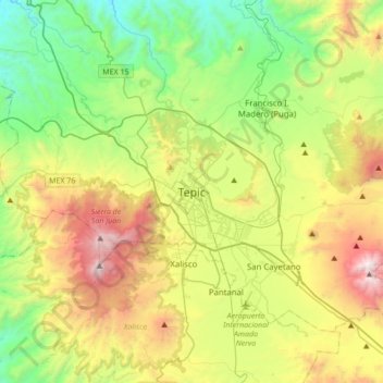
Name: Topografische Karte Tepic, Höhe, Relief.

Ort: Tepic, Municipio de Tepic, Nayarit, 63009, Mexico (21.34434 -105.05468 21.66434 -104.73468)

Durchschnittliche Höhe: 927 m

Minimale Höhe: 185 m

Maximale Höhe: 2.309 m

Located in the central part of the state, it stands at an altitude of 915 metres (3,002 ft) above sea level, on the banks of the Río Mololoa and the Río Tepic, approximately 225 kilometres (140 mi) north-west of Guadalajara, Jalisco. Nearby are the extinct Sangangüey volcano and its crater lake. Tepic is the primary urban center of this rich agricultural region; major crops include sugarcane, tobacco and citrus fruits.

Wikipedia (CC-BY-SA 3.0)

Andere topografische Karten

Klicken Sie auf eine Karte, um ihre Topografie, ihre Höhe und ihr Relief anzuzeigen.

Guayabitos

Mexico > Nayarit > Municipio de Tepic > La Libertad

Guayabitos, La Libertad, Municipio de Tepic, Nayarit, 63711, Mexico

Durchschnittliche Höhe: 1.126 m