
Topografische Karte Adelaide
Interaktive Karte
Klicken Sie auf die Karte, um die Höhe anzuzeigen.
Adelaide
Adelaide liegt nördlich der Fleurieu-Halbinsel, zwischen dem Gulf Saint Vincent und dem Mount-Lofty-Gebirge. Die Stadt erstreckt sich 20 km von der Küste bis zu den Ausläufern des Gebirges. Nach den Angaben des australischen Amtes für Statistik (Australian Bureau of Statistics) hat die Metropolregion Adelaide eine Fläche von insgesamt 870 km² und liegt durchschnittlich auf einer Höhe von 50 m. Der Mount Lofty ist mit 727 Metern der höchste Punkt der Metropolregion.
Über diese Karte
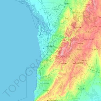
Name: Topografische Karte Adelaide, Höhe, Relief.
Ort: Adelaide, Adelaide City Council, Südaustralien, Australien (-35.35030 138.42814 -34.57224 138.84791)
Durchschnittliche Höhe: 146 m
Minimale Höhe: -1 m
Maximale Höhe: 709 m