
Topografische Karte Astrachan
Interaktive Karte
Klicken Sie auf die Karte, um die Höhe anzuzeigen.
Astrachan
Nach der Eroberung durch den Moskauer Staat wurde die Stadt 1558 als hölzerne Festung an ihrer jetzigen Lage auf einer von Wolgaarmen umflossenen Anhöhe, 12 km stromabwärts, neu aufgebaut. Ein tatarisch-osmanischer Angriff auf die Stadt 1569 scheiterte. 1582 erhielt der Ort eine Zitadelle, den Astrachaner Kreml mit einer steinernen Mauer mit acht Türmen und eine Karawanserei. Um den Kreml herum bildeten sich Freie Siedlungen (eine sogenannte Sloboda-Siedlung) der Astrachaner Tataren, Armenier und Russen. Die an der Peripherie des russischen Zarenreichs gelegene Festung war den Angriffen der an den Flüssen Don, Terek und Wolga siedelnden Kosaken, der ursprünglichen regionalen Bevölkerung und benachbarter Nachfolgereiche der ehemaligen Goldenen Horde wie des Krimkhanates ausgesetzt. Sie wehrten sich gegen die vom Astrachaner Kreml ausgehende Herrschaft oder sahen diese und die russische Ansiedlung als Fremdherrschaft und Bedrohung an (Aufstand von 1605/06, Eroberung der Stadt durch die Donkosaken unter Stepan Rasin 1670/71).
Über diese Karte
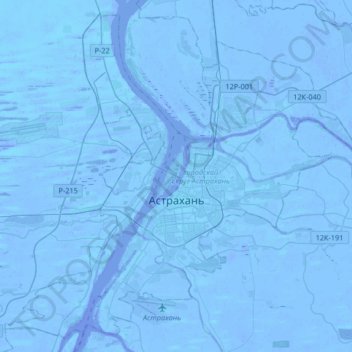
Name: Topografische Karte Astrachan, Höhe, Relief.
Durchschnittliche Höhe: -21 m
Minimale Höhe: -30 m
Maximale Höhe: -6 m