Geolokalisieren

Topografische Karte Ramsgate

Interaktive Karte

Klicken Sie auf die Karte, um die Höhe anzuzeigen.

Über diese Karte

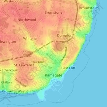
Name: Topografische Karte Ramsgate, Höhe, Relief.

Ort: Ramsgate, Thanet, Kent, England, United Kingdom (51.32210 1.37687 51.36087 1.44107)

Durchschnittliche Höhe: 25 m

Minimale Höhe: 0 m

Maximale Höhe: 55 m

In 2017 Ramsgate was chosen as one of the first ten Heritage Action Zones (HAZ) by Historic England, with the aim of stimulating economic growth using Ramsgate's historic environment as a catalyst. Part of this project included a Historic Landscape Characterisation Study which assessed and mapped the patterns of historic character in the town, using geological and topographical surveys, and covering aspects from the Neolithic, medieval, Georgian, Victorian, and through to the First and Second World War periods.

Wikipedia (CC-BY-SA 3.0)

Andere topografische Karten

Klicken Sie auf eine Karte, um ihre Topografie, ihre Höhe und ihr Relief anzuzeigen.

St Nicholas-at-Wade

United Kingdom > England > Kent > Thanet

St Nicholas-at-Wade, Thanet, Kent, England, United Kingdom

Durchschnittliche Höhe: 8 m

Margate

United Kingdom > England > Kent > Thanet

Margate, Thanet, Kent, England, United Kingdom

Durchschnittliche Höhe: 22 m