Spenden
Topografische Karte Norwich
Klicken Sie auf die Karte, um die Höhe anzuzeigen.
Spenden
Über diese Karte
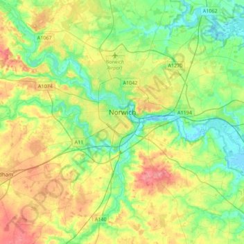
Name: Topografische Karte Norwich, Höhe, Relief.
Ort: Norwich, Norfolk, England, United Kingdom (52.55544 1.20387 52.68491 1.54078)
Durchschnittliche Höhe: 28 m
Minimale Höhe: -6 m
Maximale Höhe: 74 m
Spenden
Andere topografische Karten
Klicken Sie auf eine Karte, um ihre Topografie, ihre Höhe und ihr Relief anzuzeigen.
King's Lynn
United Kingdom > England > Norfolk > King's Lynn and West Norfolk
Durchschnittliche Höhe: 7 m
Bagthorpe
United Kingdom > England > Norfolk > King's Lynn and West Norfolk
Durchschnittliche Höhe: 63 m
Spenden
Spenden
Spenden
St John's Fen End
United Kingdom > England > Norfolk > King's Lynn and West Norfolk
Durchschnittliche Höhe: 1 m
Brandon Bank
United Kingdom > England > Norfolk > King's Lynn and West Norfolk > Feltwell
Durchschnittliche Höhe: -1 m
Town Hill
United Kingdom > England > Norfolk > North Norfolk > West Runton
Durchschnittliche Höhe: 50 m
Spenden
Beacon Hill
United Kingdom > England > Norfolk > North Norfolk
Beacon Hill is a part of the Cromer Ridge which is a ridge of old glacial moraines (terminal moraine) that stands next to the coast above Cromer. The Cromer Ridge seems to have been the front line of the ice sheet for some time at the last glaciations, which is shown by the large size of the feature. All the…
Durchschnittliche Höhe: 65 m
Stalham Green
United Kingdom > England > Norfolk > North Norfolk > Stalham Green
Durchschnittliche Höhe: 5 m
Spenden
Johnson Street
United Kingdom > England > Norfolk > North Norfolk > Ludham > Johnson Street
Durchschnittliche Höhe: 3 m
West Lynn
United Kingdom > England > Norfolk > King's Lynn and West Norfolk
Durchschnittliche Höhe: 4 m
Spenden
Ongar Hill
United Kingdom > England > Norfolk > King's Lynn and West Norfolk
Durchschnittliche Höhe: 3 m
Poringland Wood
United Kingdom > England > Norfolk > South Norfolk > Framingham Earl
Durchschnittliche Höhe: 50 m
Pollard Street
United Kingdom > England > Norfolk > North Norfolk > Bacton
Durchschnittliche Höhe: 15 m
Spenden
Great Witchingham Village Hall Park
United Kingdom > England > Norfolk > Broadland > Lenwade > Great Witchingham
Durchschnittliche Höhe: 26 m
Spenden
The Prospect (artificial hill)
United Kingdom > England > Norfolk > Norwich
Durchschnittliche Höhe: 25 m
Haveringland Lake
United Kingdom > England > Norfolk > Broadland > Haveringland
Durchschnittliche Höhe: 39 m
Great Bircham
United Kingdom > England > Norfolk > King's Lynn and West Norfolk
Durchschnittliche Höhe: 61 m
Spenden
Calthorpe Street
United Kingdom > England > Norfolk > North Norfolk > Ingham
Durchschnittliche Höhe: 3 m
Spenden
Roudham
United Kingdom > England > Norfolk > Breckland District > Bridgham
Durchschnittliche Höhe: 31 m
Spenden
The Eye
United Kingdom > England > Norfolk > North Norfolk > Cley next the Sea
Durchschnittliche Höhe: 2 m
Spenden
North Walsham and Dilham Canal
United Kingdom > England > Norfolk > North Norfolk > Honing
Durchschnittliche Höhe: 21 m
Spenden
Three Holes
United Kingdom > England > Norfolk > King's Lynn and West Norfolk
Durchschnittliche Höhe: 2 m
Bircham Tofts
United Kingdom > England > Norfolk > King's Lynn and West Norfolk > Great Bircham
Durchschnittliche Höhe: 63 m
Brancaster Staithe
United Kingdom > England > Norfolk > King's Lynn and West Norfolk
Durchschnittliche Höhe: 18 m
Spenden
Methwold Hythe
United Kingdom > England > Norfolk > King's Lynn and West Norfolk > Methwold
Durchschnittliche Höhe: 8 m
Flaxley
United Kingdom > England > Norfolk > King's Lynn and West Norfolk > Holme next the Sea
Durchschnittliche Höhe: 8 m
Spenden
Grimston
United Kingdom > England > Norfolk > King's Lynn and West Norfolk
Durchschnittliche Höhe: 24 m
Spenden
Fundenhall
United Kingdom > England > Norfolk > South Norfolk > Ashwellthorpe and Fundenhall
Durchschnittliche Höhe: 50 m
Spenden
Spenden
Kirby Row
United Kingdom > England > Norfolk > South Norfolk > Kirby Cane
Durchschnittliche Höhe: 16 m
Spenden
Old Hunstanton Lighthouse
United Kingdom > England > Norfolk > King's Lynn and West Norfolk > Hunstanton > Old Hunstanton
Durchschnittliche Höhe: 9 m
Saham Hills
United Kingdom > England > Norfolk > Breckland District > Saham Toney
Durchschnittliche Höhe: 61 m
Thurlton Links
United Kingdom > England > Norfolk > South Norfolk > Thurlton
Durchschnittliche Höhe: 14 m
Ridlington
United Kingdom > England > Norfolk > North Norfolk > Witton and Ridlington
Durchschnittliche Höhe: 9 m
Spenden
Walpole St Andrew
United Kingdom > England > Norfolk > King's Lynn and West Norfolk
Durchschnittliche Höhe: 3 m
Ely-Ouse-Essex Water Transfer Scheme
United Kingdom > England > Norfolk > King's Lynn and West Norfolk > Hockwold cum Wilton
Durchschnittliche Höhe: 4 m
Spenden
Spenden
St John's Highway
United Kingdom > England > Norfolk > King's Lynn and West Norfolk
Durchschnittliche Höhe: 2 m
Spenden
Haverscroft Street
United Kingdom > England > Norfolk > Breckland District > Attleborough
Durchschnittliche Höhe: 34 m
Spenden
Sandringham Estate
United Kingdom > England > Norfolk > King's Lynn and West Norfolk > Sandringham
Durchschnittliche Höhe: 25 m
Highoak
United Kingdom > England > Norfolk > South Norfolk > Morley St Botolph
Durchschnittliche Höhe: 47 m
Spenden
