Geolokalisieren

Topografische Karte Peterborough

Interaktive Karte

Klicken Sie auf die Karte, um die Höhe anzuzeigen.

Über diese Karte

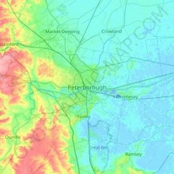
Name: Topografische Karte Peterborough, Höhe, Relief.

Ort: Peterborough, City of Peterborough, Cambridgeshire and Peterborough, England, PE1 1XH, United Kingdom (52.41258 -0.40273 52.73258 -0.08273)

Durchschnittliche Höhe: 17 m

Minimale Höhe: -19 m

Maximale Höhe: 92 m

The local topography is flat, and in some places, the land lies below sea level, for example in parts of the Fens to the east and to the south of Peterborough. Human settlement in the area began before the Bronze Age, as can be seen at the Flag Fen archaeological site to the east of the current city centre, also with evidence of Roman occupation. The Anglo-Saxon period saw the establishment of a monastery, Medeshamstede, which later became Peterborough Cathedral.

Wikipedia (CC-BY-SA 3.0)

Andere topografische Karten

Klicken Sie auf eine Karte, um ihre Topografie, ihre Höhe und ihr Relief anzuzeigen.

Castor

United Kingdom > England > City of Peterborough

Castor, City of Peterborough, Cambridgeshire and Peterborough, England, United Kingdom

Durchschnittliche Höhe: 25 m

Thorney

United Kingdom > England > City of Peterborough

Thorney, City of Peterborough, Cambridgeshire and Peterborough, England, United Kingdom

Durchschnittliche Höhe: 2 m

Northborough

United Kingdom > England > City of Peterborough

Northborough, City of Peterborough, Cambridgeshire and Peterborough, England, United Kingdom

Durchschnittliche Höhe: 8 m