
Topografische Karte Dunloe ED
Interaktive Karte
Klicken Sie auf die Karte, um die Höhe anzuzeigen.
Über diese Karte
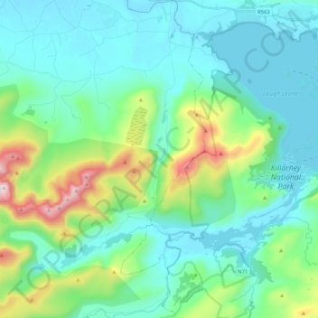
Name: Topografische Karte Dunloe ED, Höhe, Relief.
Durchschnittliche Höhe: 214 m
Minimale Höhe: 12 m
Maximale Höhe: 1.017 m
Andere topografische Karten
Klicken Sie auf eine Karte, um ihre Topografie, ihre Höhe und ihr Relief anzuzeigen.
Ballyseedy Wood
Ballyseedy Wood, Ballyseedy ED, Tralee Municipal District, County Kerry, Munster, Ireland
Durchschnittliche Höhe: 20 m
Shronowen
Shronowen, Shronowen ED, Listowel Municipal District, County Kerry, Munster, Ireland
Durchschnittliche Höhe: 27 m
Torc Mountain
Torc Mountain, Killarney Municipal District, County Kerry, Munster, V93 RR59, Ireland
Durchschnittliche Höhe: 202 m
Lisselton
Lisselton, Listowel Municipal District, County Kerry, Munster, Ireland
Durchschnittliche Höhe: 34 m
Farranfore
Farranfore, Tralee Municipal District, County Kerry, Munster, V93 YP44, Ireland
Durchschnittliche Höhe: 59 m
Stradbally Mountain
Stradbally Mountain, Kenmare Municipal District, County Kerry, Munster, Ireland
Durchschnittliche Höhe: 487 m
Glencar
Glencar, Kenmare Municipal District, County Kerry, Munster, Ireland
Durchschnittliche Höhe: 114 m
Cahersiveen
Cahersiveen, County Kerry, Munster, V23 FF95, Ireland
Durchschnittliche Höhe: 66 m
Kilgarvan
Kilgarvan, Kilgarvan ED, Kenmare Municipal District, County Kerry, Munster, Ireland
Durchschnittliche Höhe: 71 m
Brosna
Brosna, Tralee Municipal District, County Kerry, Munster, Ireland
Durchschnittliche Höhe: 163 m
Killarney
Killarney, Killarney Municipal District, County Kerry, Munster, Ireland
Durchschnittliche Höhe: 57 m
Rathmore
Rathmore, Rathmore ED, Killarney Municipal District, County Kerry, Munster, P51 PT66, Ireland
Durchschnittliche Höhe: 149 m
Lispole
Lispole, Kenmare Municipal District, County Kerry, Munster, V92 DN23, Ireland
Durchschnittliche Höhe: 107 m
Kilcummin
Kilcummin, Kilcummin ED, Killarney Municipal District, County Kerry, Munster, Ireland
Durchschnittliche Höhe: 142 m
Cromane Upper
Cromane Upper, Killorglin ED, Kenmare Municipal District, County Kerry, Munster, Ireland
Durchschnittliche Höhe: 18 m
Killorglin
Killorglin, Killorglin ED, Kenmare Municipal District, County Kerry, Munster, Ireland
Durchschnittliche Höhe: 23 m
Lyreboy
Lyreboy, Maum ED, Kenmare Municipal District, County Kerry, Munster, Ireland
Durchschnittliche Höhe: 342 m
Killarney
Killarney, Killarney Urban ED, Killarney Municipal District, County Kerry, Munster, Ireland
Durchschnittliche Höhe: 39 m
Glenmore
Glenmore, Glanmore ED, Kenmare Municipal District, County Kerry, Munster, Ireland
Durchschnittliche Höhe: 269 m
Glanmore
Glanmore, Kilgobban ED, Kenmare Municipal District, County Kerry, Munster, Ireland
Durchschnittliche Höhe: 187 m
Beheenagh
Beheenagh, Kilgobban ED, Kenmare Municipal District, County Kerry, Munster, Ireland
Durchschnittliche Höhe: 347 m
Banna Strand
Banna Strand, Banna ED, Tralee Municipal District, County Kerry, Munster, Ireland
Durchschnittliche Höhe: 4 m
Lauragh
Lauragh, Kenmare Municipal District, County Kerry, Munster, Ireland
Durchschnittliche Höhe: 89 m
Killarney
Ireland > County Kerry > Killarney
Killarney, Killarney Municipal District, County Kerry, Munster, V93 AYP9, Ireland
Durchschnittliche Höhe: 66 m
Glashanacree
Glashanacree, Kilshenane ED, Tralee Municipal District, County Kerry, Munster, Ireland
Durchschnittliche Höhe: 143 m
Derrybanane
Derrybanane, Flesk ED, Killarney Municipal District, County Kerry, Munster, Ireland
Durchschnittliche Höhe: 299 m
Valencia Island
Valencia Island, Kenmare Municipal District, County Kerry, Munster, Ireland
Durchschnittliche Höhe: 39 m
Barrow
Barrow, Ballynahaglish ED, Tralee Municipal District, County Kerry, Munster, Ireland
Durchschnittliche Höhe: 7 m
Lough Guitane
Lough Guitane, Flesk ED, Killarney Municipal District, County Kerry, Munster, Ireland
Durchschnittliche Höhe: 112 m
Knoppoge
Knoppoge, Ballyduff ED, Listowel Municipal District, County Kerry, Munster, Ireland
Durchschnittliche Höhe: 29 m
Gunsborough
Gunsborough, Gunsborough ED, Listowel Municipal District, County Kerry, Munster, V31 TR74, Ireland
Durchschnittliche Höhe: 54 m
Barraduff
Ireland > County Kerry > Barraduff
Barraduff, Killarney Municipal District, County Kerry, Munster, Ireland
Durchschnittliche Höhe: 124 m
Knocknacree
Knocknacree, Ballyduff ED, Listowel Municipal District, County Kerry, Munster, Ireland
Durchschnittliche Höhe: 51 m
Pallis
Pallis, Lahard ED, Killarney Municipal District, County Kerry, Munster, Ireland
Durchschnittliche Höhe: 48 m
Ballincolla
Ballincolla, Dunurlin ED, Kenmare Municipal District, County Kerry, Munster, Ireland
Durchschnittliche Höhe: 22 m
Rattoo Round Tower
Rattoo Round Tower, R551, Ballyduff ED, Listowel Municipal District, County Kerry, Munster, Ireland
Durchschnittliche Höhe: 16 m
Knockbrack
Knockbrack, Ballynorig ED, Listowel Municipal District, County Kerry, Munster, Ireland
Durchschnittliche Höhe: 20 m
Heirhill
Heirhill, Ballyheige ED, Listowel Municipal District, County Kerry, Munster, Ireland
Durchschnittliche Höhe: 54 m
Raheens
Raheens, Bahaghs ED, Kenmare Municipal District, County Kerry, Munster, Ireland
Durchschnittliche Höhe: 166 m
Ballintobernig
Ballintobernig, Ratass ED, Tralee Municipal District, County Kerry, Munster, Ireland
Durchschnittliche Höhe: 182 m
Castlelough
Castlelough, Muckross ED, Killarney Municipal District, County Kerry, Munster, V93 RR59, Ireland
Durchschnittliche Höhe: 35 m
Drombeg
Drombeg, Shronowen ED, Listowel Municipal District, County Kerry, Munster, Ireland
Durchschnittliche Höhe: 43 m
Knockglass Beg
Knockglass Beg, Knockglass ED, Kenmare Municipal District, County Kerry, Munster, Ireland
Durchschnittliche Höhe: 94 m
Ballydunlea
Ballydunlea, Tralee Rural ED, Tralee Municipal District, County Kerry, Munster, Ireland
Durchschnittliche Höhe: 158 m
Ballyconnell
Ballyconnell, Kilfeighny ED, Listowel Municipal District, County Kerry, Munster, Ireland
Durchschnittliche Höhe: 41 m
Coolroe Upper
Coolroe Upper, Glanbehy ED, Kenmare Municipal District, County Kerry, Munster, Ireland
Durchschnittliche Höhe: 178 m