
Topografische Karte Indiana
Interaktive Karte
Klicken Sie auf die Karte, um die Höhe anzuzeigen.
Über diese Karte
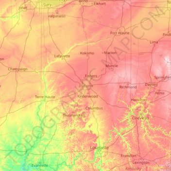
Name: Topografische Karte Indiana, Höhe, Relief.
Ort: Indiana, United States (37.77174 -88.09970 41.76137 -84.78461)
Durchschnittliche Höhe: 226 m
Minimale Höhe: 103 m
Maximale Höhe: 458 m
The average altitude of Indiana is about 760 feet (230 m) above sea level. The highest point in the state is Hoosier Hill in Wayne County at 1,257 feet (383 m) above sea level. The lowest point at 320 feet (98 m) above sea level is in Posey County, where the Wabash River meets the Ohio River. The resulting elevation span, 937 feet (286 m), is the narrowest of any non-coastal U.S. state. Only 2,850 square miles (7,400 km2) have an altitude greater than 1,000 feet (300 m) and this area is enclosed within 14 counties. About 4,700 square miles (12,000 km2) have an elevation of less than 500 feet (150 m), mostly concentrated along the Ohio and lower Wabash Valleys, from Tell City and Terre Haute to Evansville and Mount Vernon.
Andere topografische Karten
Klicken Sie auf eine Karte, um ihre Topografie, ihre Höhe und ihr Relief anzuzeigen.
Los Angeles
Los Angeles, California, United States
Durchschnittliche Höhe: 241 m
Brooklyn
United States > New York > New York
Brooklyn, Kings County, New York, United States
Durchschnittliche Höhe: 9 m
New Orleans
United States > Louisiana > Orleans Parish
New Orleans, Orleans Parish, Louisiana, United States
Durchschnittliche Höhe: 1 m
Houston
United States > Texas > Harris County
Houston, Harris County, Texas, United States
Durchschnittliche Höhe: 25 m
Santa Cruz
United States > California > Santa Cruz County
Santa Cruz, Santa Cruz County, California, United States
Durchschnittliche Höhe: 89 m
Sacramento
United States > California > Sacramento County
Sacramento, Sacramento County, California, United States
Durchschnittliche Höhe: 10 m
Jacksonville
United States > Florida > Duval County
Jacksonville, Duval County, Florida, United States
Durchschnittliche Höhe: 10 m
Albuquerque
United States > New Mexico > Bernalillo County
Albuquerque, Bernalillo County, New Mexico, United States
Durchschnittliche Höhe: 1.688 m
Somerville
United States > Massachusetts > Middlesex County
Somerville, Middlesex County, Massachusetts, United States
Durchschnittliche Höhe: 11 m
Spokane
United States > Washington > Spokane County
Spokane, Spokane County, Washington, United States
Durchschnittliche Höhe: 655 m
Madison
United States > Wisconsin > Dane County
Madison, Dane County, Wisconsin, United States
Durchschnittliche Höhe: 284 m
Staten Island
United States > New York > New York
Staten Island, Richmond County, New York, United States
Durchschnittliche Höhe: 9 m
Baltimore
United States > Maryland > Baltimore
Baltimore, Maryland, 21233, United States
Durchschnittliche Höhe: 65 m
Lancaster County
Lancaster County, Pennsylvania, United States
Durchschnittliche Höhe: 158 m
Missoula
United States > Montana > Missoula County
Missoula, Missoula County, Montana, United States
Durchschnittliche Höhe: 1.173 m
Santa Fe
United States > New Mexico > Santa Fe County
Santa Fe, Santa Fe County, New Mexico, United States
Durchschnittliche Höhe: 2.221 m
Cambridge
United States > Massachusetts > Middlesex County
Cambridge, Middlesex County, Massachusetts, United States
Durchschnittliche Höhe: 11 m
Brunswick County
United States > North Carolina
Brunswick County, North Carolina, United States
Durchschnittliche Höhe: 9 m
Kauai
United States > Hawaii > Kauaʻi County
Kauai, Kauaʻi County, Hawaii, United States
Durchschnittliche Höhe: 216 m
Queens County
United States > New York > New York
Queens County, New York, United States
Durchschnittliche Höhe: 11 m