
Topografische Karte Leh
Interaktive Karte
Klicken Sie auf die Karte, um die Höhe anzuzeigen.
Über diese Karte
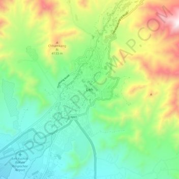
Name: Topografische Karte Leh, Höhe, Relief.
Ort: Leh, Leh Tehsil, Leh District, Ladakh, India (34.12420 77.54481 34.20420 77.62481)
Durchschnittliche Höhe: 3.653 m
Minimale Höhe: 3.206 m
Maximale Höhe: 4.572 m
Leh (/ˈlɛ/) (Ladakhi: གླེ) is the joint capital and largest city of Ladakh, a union territory of India. Leh, located in the Leh district, was also the historical capital of the Kingdom of Ladakh, the seat of which was in the Leh Palace, the former residence of the royal family of Ladakh, built in the same style and about the same time as the Potala Palace in Tibet. Leh is at an altitude of 3,524 m (11,562 ft), and is connected via National Highway 1 to Srinagar in the southwest and to Manali in the south via the Leh-Manali Highway (part of National Highway 3 connect leh).
Andere topografische Karten
Klicken Sie auf eine Karte, um ihre Topografie, ihre Höhe und ihr Relief anzuzeigen.
Dungti
India > Ladakh > Leh Tehsil
Dungti, Leh Tehsil, Leh District, Ladakh, India
Durchschnittliche Höhe: 4.281 m
Mudh
India > Ladakh > Leh Tehsil
Mudh, Leh Tehsil, Leh District, Ladakh, 194404, India
Durchschnittliche Höhe: 4.324 m
Mahe
India > Ladakh > Leh Tehsil
Mahe, Leh Tehsil, Leh District, Ladakh, India
Durchschnittliche Höhe: 4.403 m
Nimo
India > Ladakh > Leh Tehsil
Nimo, Leh Tehsil, Leh District, Ladakh, India
Durchschnittliche Höhe: 3.282 m
Sakti
India > Ladakh > Leh Tehsil
Sakti, Leh Tehsil, Leh district, Ladakh, India
Durchschnittliche Höhe: 3.842 m
Pharka
India > Ladakh > Leh Tehsil > Spituk
Pharka, Spituk, Leh Tehsil, Leh district, Ladakh, India
Durchschnittliche Höhe: 3.269 m
Lato
India > Ladakh > Leh Tehsil
Lato, Leh Tehsil, Leh district, Ladakh, India
Durchschnittliche Höhe: 4.268 m
Kang Yatse 4 North
India > Ladakh > Leh Tehsil
Kang Yatse 4 North, Leh Tehsil, Leh district, Ladakh, India
Durchschnittliche Höhe: 5.759 m
Phyang
India > Ladakh > Leh Tehsil
Phyang, Leh Tehsil, Leh district, Ladakh, 194101, India
Durchschnittliche Höhe: 3.742 m
Khardung La
India > Ladakh > Leh Tehsil
Khardung La, Leh Tehsil, Leh district, Ladakh, India
Durchschnittliche Höhe: 5.236 m
Chinese claimed Pangong Tso area
India > Ladakh > Leh Tehsil
Chinese claimed Pangong Tso area, Leh Tehsil, Leh district, Ladakh, India
Durchschnittliche Höhe: 4.361 m
Korzok Kangri
India > Ladakh > Leh Tehsil
Korzok Kangri, Leh Tehsil, Leh district, Ladakh, India
Durchschnittliche Höhe: 5.635 m
Chemre
India > Ladakh > Leh Tehsil > Chemre
Chemre, Leh Tehsil, Leh district, Ladakh, India
Durchschnittliche Höhe: 3.711 m
Shey
India > Ladakh > Leh Tehsil > Shey
Shey, Leh Tehsil, Leh district, Ladakh, 194201, India
Durchschnittliche Höhe: 3.282 m
Spituk
India > Ladakh > Leh Tehsil > Spituk
Spituk, Leh Tehsil, Leh district, Ladakh, India
Durchschnittliche Höhe: 3.253 m
Nyoma
India > Ladakh > Leh Tehsil
Nyoma, Leh Tehsil, Leh District, Ladakh, 194404, India
Durchschnittliche Höhe: 4.260 m
Stok
India > Ladakh > Leh Tehsil
Stok, Leh Tehsil, Leh district, Ladakh, India
Durchschnittliche Höhe: 3.580 m
Tso Moriri
India > Ladakh > Leh Tehsil > Karzok
Tso Moriri, Karzok, Leh Tehsil, Leh district, Ladakh, India
Durchschnittliche Höhe: 5.044 m
Chumathang
India > Ladakh > Leh Tehsil
Chumathang, Leh Tehsil, Leh District, Ladakh, India
Durchschnittliche Höhe: 4.335 m