
Topografische Karte Leclercville
Interaktive Karte
Klicken Sie auf die Karte, um die Höhe anzuzeigen.
Über diese Karte
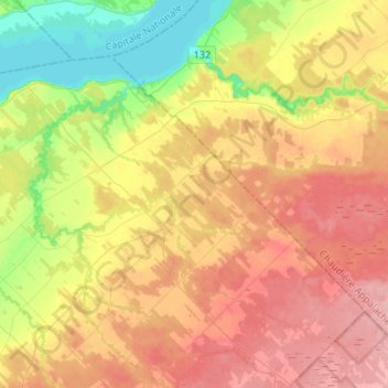
Name: Topografische Karte Leclercville, Höhe, Relief.
Durchschnittliche Höhe: 62 m
Minimale Höhe: 0 m
Maximale Höhe: 121 m
Andere topografische Karten
Klicken Sie auf eine Karte, um ihre Topografie, ihre Höhe und ihr Relief anzuzeigen.
Saint-Agapit
Canada > Québec > Lotbinière (MRC)
Saint-Agapit, Lotbinière (MRC), Chaudière-Appalaches, Québec, G0S 1Z0, Canada
Durchschnittliche Höhe: 130 m
Notre-Dame-du-Sacré-Coeur-d'Issoudun
Canada > Québec > Lotbinière (MRC)
Notre-Dame-du-Sacré-Coeur-d'Issoudun, Lotbinière (MRC), Chaudière-Appalaches, Québec, Canada
Durchschnittliche Höhe: 99 m
Saint-Édouard-de-Lotbinière
Canada > Québec > Lotbinière (MRC)
Saint-Édouard-de-Lotbinière, Lotbinière (MRC), Chaudière-Appalaches, Québec, G0S 1Y0, Canada
Durchschnittliche Höhe: 75 m
Saint-Antoine-de-Tilly
Canada > Québec > Lotbinière (MRC)
Saint-Antoine-de-Tilly, Lotbinière (MRC), Chaudière-Appalaches, Québec, Canada
Durchschnittliche Höhe: 71 m
Lotbinière
Canada > Québec > Lotbinière (MRC)
Lotbinière, Lotbinière (MRC), Chaudière-Appalaches, Québec, Canada
Durchschnittliche Höhe: 38 m
Saint-Apollinaire
Canada > Québec > Lotbinière (MRC)
Saint-Apollinaire, Lotbinière (MRC), Chaudière-Appalaches, Québec, G0S 2E0, Canada
Durchschnittliche Höhe: 110 m
Saint-Sylvestre
Canada > Québec > Lotbinière (MRC) > Saint-Sylvestre
Saint-Sylvestre, Lotbinière (MRC), Chaudière-Appalaches, Québec, G0S 3C0, Canada
Durchschnittliche Höhe: 307 m
Fleuve Saint-Laurent, Estuaire fluvial
Canada > Québec > Lotbinière (MRC)
Fleuve Saint-Laurent, Estuaire fluvial, Lotbinière (MRC), Chaudière-Appalaches, Québec, G1E 3M3, Canada
Durchschnittliche Höhe: 266 m
Saint-Gilles
Canada > Québec > Lotbinière (MRC)
Saint-Gilles, Lotbinière (MRC), Chaudière-Appalaches, Québec, G0S 2P0, Canada
Durchschnittliche Höhe: 139 m
Saint-Antoine de Tilly
Canada > Québec > Lotbinière (MRC) > Saint-Antoine-de-Tilly
Saint-Antoine de Tilly, Saint-Antoine-de-Tilly, Lotbinière (MRC), Chaudière-Appalaches, Québec, G0A 2R0, Canada
Durchschnittliche Höhe: 32 m
Rivière Saint-Georges
Canada > Québec > Lotbinière (MRC) > Sainte-Agathe-de-Lotbinière
Rivière Saint-Georges, Sainte-Agathe-de-Lotbinière, Lotbinière (MRC), Chaudière-Appalaches, Québec, G0S 2A0, Canada
Durchschnittliche Höhe: 158 m
Ruisseau Sainte-Croix
Canada > Québec > Lotbinière (MRC) > Sainte-Agathe-de-Lotbinière
Ruisseau Sainte-Croix, Sainte-Agathe-de-Lotbinière, Lotbinière (MRC), Chaudière-Appalaches, Québec, G0S 2A0, Canada
Durchschnittliche Höhe: 228 m
Val-Alain
Canada > Québec > Lotbinière (MRC)
Val-Alain, Lotbinière (MRC), Chaudière-Appalaches, Québec, Canada
Durchschnittliche Höhe: 119 m
Saint-Patrice-de-Beaurivage
Canada > Québec > Lotbinière (MRC)
Saint-Patrice-de-Beaurivage, Lotbinière (MRC), Chaudière-Appalaches, Québec, G0S 1B0, Canada
Durchschnittliche Höhe: 215 m
Sainte-Agathe-de-Lotbinière
Canada > Québec > Lotbinière (MRC)
Sainte-Agathe-de-Lotbinière, Lotbinière (MRC), Chaudière-Appalaches, Québec, G0S 2A0, Canada
Durchschnittliche Höhe: 195 m
Laurier-Station
Canada > Québec > Lotbinière (MRC)
Laurier-Station, Lotbinière (MRC), Chaudière-Appalaches, Québec, G0S 1N0, Canada
Durchschnittliche Höhe: 114 m
Pointe-Platon
Canada > Québec > Lotbinière (MRC) > Lotbinière
Pointe-Platon, Lotbinière, Lotbinière (MRC), Chaudière-Appalaches, Québec, G0A 2Y0, Canada
Durchschnittliche Höhe: 26 m