
Topografische Karte Foynes Island
Interaktive Karte
Klicken Sie auf die Karte, um die Höhe anzuzeigen.
Über diese Karte
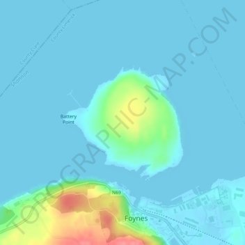
Name: Topografische Karte Foynes Island, Höhe, Relief.
Durchschnittliche Höhe: 10 m
Minimale Höhe: -2 m
Maximale Höhe: 74 m
Andere topografische Karten
Klicken Sie auf eine Karte, um ihre Topografie, ihre Höhe und ihr Relief anzuzeigen.
Knocknabooly East
Ireland > The Municipal District of Adare — Rathkeale
Knocknabooly East, Loghill, The Municipal District of Adare — Rathkeale, County Limerick, Munster, Ireland
Durchschnittliche Höhe: 105 m
Glendiheen
Ireland > The Municipal District of Adare — Rathkeale
Glendiheen, Dunmoylan East, The Municipal District of Adare — Rathkeale, County Limerick, Munster, Ireland
Durchschnittliche Höhe: 167 m
Shanagolden
Ireland > The Municipal District of Adare — Rathkeale
Shanagolden, The Municipal District of Adare — Rathkeale, County Limerick, Munster, Ireland
Durchschnittliche Höhe: 40 m
Pallaskenry
Ireland > The Municipal District of Adare — Rathkeale
Pallaskenry, The Municipal District of Adare — Rathkeale, County Limerick, Munster, Ireland
Durchschnittliche Höhe: 11 m
Loghill
Ireland > The Municipal District of Adare — Rathkeale
Loghill, The Municipal District of Adare — Rathkeale, County Limerick, Munster, Ireland
Durchschnittliche Höhe: 69 m
Ballinknockane
Ireland > The Municipal District of Adare — Rathkeale
Ballinknockane, Craggs, The Municipal District of Adare — Rathkeale, County Limerick, Munster, Ireland
Durchschnittliche Höhe: 27 m
Inchinclare
Ireland > The Municipal District of Adare — Rathkeale
Inchinclare, Ballynabanoge, The Municipal District of Adare — Rathkeale, County Limerick, Munster, Ireland
Durchschnittliche Höhe: 41 m
Clonshire Beg
Ireland > The Municipal District of Adare — Rathkeale
Clonshire Beg, Croagh, The Municipal District of Adare — Rathkeale, County Limerick, Munster, Ireland
Durchschnittliche Höhe: 13 m
Kildimo
Ireland > The Municipal District of Adare — Rathkeale
Kildimo, The Municipal District of Adare — Rathkeale, County Limerick, Munster, Ireland
Durchschnittliche Höhe: 14 m