
Topografische Karte Udaipur
Interaktive Karte
Klicken Sie auf die Karte, um die Höhe anzuzeigen.
Über diese Karte
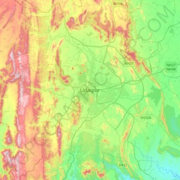
Name: Topografische Karte Udaipur, Höhe, Relief.
Durchschnittliche Höhe: 656 m
Minimale Höhe: 408 m
Maximale Höhe: 1.067 m
Udaipur is located at 24°31′30″N 73°40′38″E / 24.525049°N 73.677116°E / 24.525049; 73.677116. The city covers an area of 64 km2 (25 sq mi) and lies at an altitude of 598.00 m (1,962 ft) above sea level. It is located in the southern region of Rajasthan, near the Gujarat border. The city lies 403 km (250 mi) southwest of the state capital, Jaipur and 250 km (155 mi) northeast from Ahmedabad.
Andere topografische Karten
Klicken Sie auf eine Karte, um ihre Topografie, ihre Höhe und ihr Relief anzuzeigen.
Kalarwas
India > Rajasthan > Girwa Tehsil
Kalarwas, Girwa Tehsil, Udaipur District, Rajasthan, India
Durchschnittliche Höhe: 583 m
Pratap Park
India > Rajasthan > Girwa Tehsil > Udaipur
Pratap Park, Udaipur, Girwa Tehsil, Udaipur District, Rajasthan, 313001, India
Durchschnittliche Höhe: 608 m
Kodiyat
India > Rajasthan > Girwa Tehsil
Kodiyat, Girwa Tehsil, Udaipur District, Rajasthan, India
Durchschnittliche Höhe: 672 m