
Topografische Karte Alice Springs
Interaktive Karte
Klicken Sie auf die Karte, um die Höhe anzuzeigen.
Über diese Karte
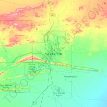
Name: Topografische Karte Alice Springs, Höhe, Relief.
Durchschnittliche Höhe: 631 m
Minimale Höhe: 505 m
Maximale Höhe: 934 m
Temperatures in Alice Springs vary widely, and rainfall can vary quite dramatically from year to year. In summer, the average maximum temperature is in the mid-30s, whereas in winter the average minimum temperature can be 5.5 °C (41.9 °F), with an average of 12.4 nights below freezing every year, providing frost. The elevation of the town is about 545 metres (1,788 feet), which contributes to the cool nights in winter. The highest temperature on record is 47.5 °C (117.5 °F) first recorded on 24 December 1891, whilst the record low is −7.5 °C (18.5 °F), recorded on 17 July 1976. This is also the lowest temperature recorded in the Northern Territory.
Andere topografische Karten
Klicken Sie auf eine Karte, um ihre Topografie, ihre Höhe und ihr Relief anzuzeigen.
Todd River
Australia > Northern Territory > Alice Springs
Todd River, Alice Springs, Town of Alice Springs, Northern Territory, 0870, Australia
Durchschnittliche Höhe: 632 m
Mount Everard
Australia > Northern Territory > Alice Springs
Mount Everard, Alice Springs, Northern Territory, Australia
Durchschnittliche Höhe: 768 m
Heavitree Gap
Australia > Northern Territory > Alice Springs
Heavitree Gap, Alice Springs, Town of Alice Springs, Northern Territory, 0870, Australia
Durchschnittliche Höhe: 590 m