
Topografische Karte Acapulco
Interaktive Karte
Klicken Sie auf die Karte, um die Höhe anzuzeigen.
Über diese Karte
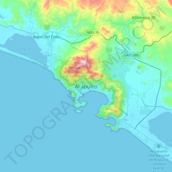
Name: Topografische Karte Acapulco, Höhe, Relief.
Ort: Acapulco, Acapulco de Juárez, Guerrero, 39300, Mexico (16.70805 -100.05402 17.02805 -99.73402)
Durchschnittliche Höhe: 99 m
Minimale Höhe: -2 m
Maximale Höhe: 932 m
The city, located on the Pacific coast of Mexico in the state of Guerrero, is classified as one of the state's seven regions, dividing the rest of the Guerrero coast into the Costa Grande and the Costa Chica. Forty percent of the municipality is mountainous terrain; another forty percent is semi-flat; and the other twenty percent is flat. Elevation varies from sea level to 1,699 metres (5,574 feet). The highest peaks are Potrero, San Nicolas, and Alto Camarón. One major river runs through the municipality, the Papagayo, along with a number of arroyos (streams). There are also two small lagoons, Tres Palos and Coyuca, along with a number of thermal springs.