
Topografische Karte Connecticut
Interaktive Karte
Klicken Sie auf die Karte, um die Höhe anzuzeigen.
Über diese Karte
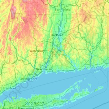
Name: Topografische Karte Connecticut, Höhe, Relief.
Ort: Connecticut, United States (40.95098 -73.72781 42.05058 -71.78724)
Durchschnittliche Höhe: 118 m
Minimale Höhe: -3 m
Maximale Höhe: 780 m
Winters (December through mid-March) are generally cold from south to north in Connecticut. The coldest month (January) has average high temperatures ranging from 38 °F (3 °C) in the coastal lowlands to 33 °F (1 °C) in the inland and northern portions on the state. The lowest temperature recorded in Connecticut is −32 °F (−36 °C) which has been observed twice: in Falls Village on February 16, 1943, and in Coventry on January 22, 1961. The average yearly snowfall ranges from about 60 inches (1,500 mm) in the higher elevations of the northern portion of the state to only 20–25 inches (510–640 mm) along the southeast coast of Connecticut (Branford to Groton). Generally, any locale north or west of Interstate 84 receives the most snow, during a storm, and throughout the season. Most of Connecticut has less than 60 days of snow cover. Snow usually falls from late November to late March in the northern part of the state, and from early December to mid-March in the southern and coastal parts of the state.
Andere topografische Karten
Klicken Sie auf eine Karte, um ihre Topografie, ihre Höhe und ihr Relief anzuzeigen.
Brooklyn
United States > New York > New York
Brooklyn, Kings County, New York, United States
Durchschnittliche Höhe: 9 m
Los Angeles
Los Angeles, California, United States
Durchschnittliche Höhe: 241 m
Houston
United States > Texas > Harris County
Houston, Harris County, Texas, United States
Durchschnittliche Höhe: 25 m
Boulder
United States > Colorado > Boulder County
Boulder, Boulder County, Colorado, United States
Durchschnittliche Höhe: 1.785 m
Albuquerque
United States > New Mexico > Bernalillo County
Albuquerque, Bernalillo County, New Mexico, United States
Durchschnittliche Höhe: 1.688 m
Amelia Island
United States > Florida > Nassau County > Fernandina Beach
Amelia Island, Fernandina Beach, Nassau County, Florida, 32034, United States
Durchschnittliche Höhe: 3 m
Appalachian Mountains
United States > North Carolina > Yancey County
Appalachian Mountains, Yancey County, North Carolina, United States
Durchschnittliche Höhe: 1.463 m
Santa Cruz
United States > California > Santa Cruz County
Santa Cruz, Santa Cruz County, California, United States
Durchschnittliche Höhe: 89 m
Baldwin County
Baldwin County, Alabama, United States
Durchschnittliche Höhe: 31 m
Brunswick County
United States > North Carolina
Brunswick County, North Carolina, United States
Durchschnittliche Höhe: 9 m
Bronx County
United States > New York > New York
Bronx County, The Bronx, New York, United States
Durchschnittliche Höhe: 21 m
Des Moines
United States > Iowa > Polk County
Des Moines, Polk County, Iowa, United States
Durchschnittliche Höhe: 264 m
Irvine
United States > California > Orange County
Irvine, Orange County, California, United States
Durchschnittliche Höhe: 66 m
Yakima County
Yakima County, Washington, United States
Durchschnittliche Höhe: 879 m
Worcester
United States > Massachusetts > Worcester County
Worcester, Worcester County, Massachusetts, United States
Durchschnittliche Höhe: 186 m
Salt Lake County
Salt Lake County, Utah, United States
Durchschnittliche Höhe: 1.811 m
Whatcom County
Whatcom County, Washington, United States
Durchschnittliche Höhe: 753 m
Corpus Christi
United States > Texas > Nueces County
Corpus Christi, Nueces County, Texas, United States
Durchschnittliche Höhe: 8 m
New Orleans
United States > Louisiana > Orleans Parish
New Orleans, Orleans Parish, Louisiana, United States
Durchschnittliche Höhe: 1 m
Fairfax County
Fairfax County, Virginia, United States
Durchschnittliche Höhe: 75 m