
Topografische Karte Methven
Interaktive Karte
Klicken Sie auf die Karte, um die Höhe anzuzeigen.
Über diese Karte
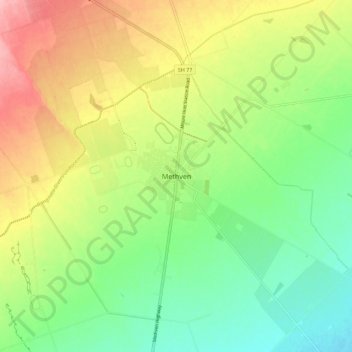
Name: Topografische Karte Methven, Höhe, Relief.
Ort: Methven, Ashburton District, Canterbury, 7730, New Zealand (-43.67243 171.60726 -43.59243 171.68726)
Durchschnittliche Höhe: 322 m
Minimale Höhe: 270 m
Maximale Höhe: 396 m
Methven (Māori: Piwakawaka) is a small town in the Canterbury region of the South Island of New Zealand. It is located near the western edge of the Canterbury Plains, 35 kilometres north of Ashburton and 95 kilometres west of Christchurch, and at an elevation of 320 m. The town is a service centre for agriculture in the surrounding area, and is a base for skiing at the nearby Mount Hutt skifield. The town slogan is "Amazing Space".
Andere topografische Karten
Klicken Sie auf eine Karte, um ihre Topografie, ihre Höhe und ihr Relief anzuzeigen.
Ōtūroto / Lake Heron
New Zealand > Canterbury > Ashburton District
Ōtūroto / Lake Heron, Ashburton District, Canterbury, New Zealand
Durchschnittliche Höhe: 750 m
Ashburton
New Zealand > Canterbury > Ashburton District
Ashburton, Ashburton District, Canterbury, 7700, New Zealand
Durchschnittliche Höhe: 99 m
Totara Peak
New Zealand > Canterbury > Ashburton District
Totara Peak, Ashburton District, Canterbury, New Zealand
Durchschnittliche Höhe: 1.645 m
Rakaia Gorge lookout
New Zealand > Canterbury > Ashburton District
Rakaia Gorge lookout, Arundel Rakaia Gorge Road, Ashburton District, Canterbury, New Zealand
Durchschnittliche Höhe: 358 m
Dromore
New Zealand > Canterbury > Ashburton District
Dromore, Ashburton District, Canterbury, 7772, New Zealand
Durchschnittliche Höhe: 123 m
Hackthorne
New Zealand > Canterbury > Ashburton District
Hackthorne, Ashburton District, Canterbury, New Zealand
Durchschnittliche Höhe: 199 m
Mayfield
New Zealand > Canterbury > Ashburton District
Mayfield, Ashburton District, Canterbury, 7778, New Zealand
Durchschnittliche Höhe: 266 m
Ashburton Lakes
New Zealand > Canterbury > Ashburton District
Ashburton Lakes, Ashburton District, Canterbury, New Zealand
Durchschnittliche Höhe: 645 m
Ruapuna
New Zealand > Canterbury > Ashburton District
Ruapuna, Ashburton District, Canterbury, New Zealand
Durchschnittliche Höhe: 302 m
Mount Somers
New Zealand > Canterbury > Ashburton District
Mount Somers, Ashburton District, Canterbury, New Zealand
Durchschnittliche Höhe: 1.221 m
Lake Clearwater
New Zealand > Canterbury > Ashburton District
Lake Clearwater, Ashburton District, Canterbury, New Zealand
Durchschnittliche Höhe: 751 m