
Topografische Karte Paraparaumu
Interaktive Karte
Klicken Sie auf die Karte, um die Höhe anzuzeigen.
Über diese Karte
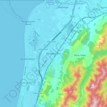
Name: Topografische Karte Paraparaumu, Höhe, Relief.
Durchschnittliche Höhe: 79 m
Minimale Höhe: -1 m
Maximale Höhe: 504 m
Andere topografische Karten
Klicken Sie auf eine Karte, um ihre Topografie, ihre Höhe und ihr Relief anzuzeigen.
Te Horo Beach
New Zealand > Wellington > Kapiti Coast District
Te Horo Beach, Kāpiti Coast District, Wellington, 5583, New Zealand
Durchschnittliche Höhe: 4 m
Waikanae
New Zealand > Wellington > Kapiti Coast District
Waikanae, Kāpiti Coast District, Wellington, 5036, New Zealand
Durchschnittliche Höhe: 112 m
Ōtaki
New Zealand > Wellington > Kapiti Coast District > Ōtaki
Ōtaki, Kapiti Coast District, Wellington, 5512, New Zealand
Durchschnittliche Höhe: 28 m
Rangiora River
New Zealand > Wellington > Kapiti Coast District
Rangiora River, Kāpiti Coast District, Wellington, New Zealand
Durchschnittliche Höhe: 120 m
Paekakariki
New Zealand > Wellington > Kapiti Coast District
Paekakariki, Kāpiti Coast District, Wellington, 5034, New Zealand
Durchschnittliche Höhe: 133 m
Kapiti Island
New Zealand > Wellington > Kapiti Coast District
Kapiti Island, Kapiti Coast District, Wellington, New Zealand
Durchschnittliche Höhe: 55 m
Ōtaki Beach
New Zealand > Wellington > Kapiti Coast District
Ōtaki Beach, Kāpiti Coast District, Wellington, 5512, New Zealand
Durchschnittliche Höhe: 8 m