
Topografische Karte Cumberland County
Interaktive Karte
Klicken Sie auf die Karte, um die Höhe anzuzeigen.
Über diese Karte
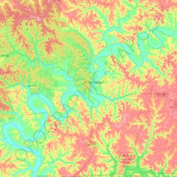
Name: Topografische Karte Cumberland County, Höhe, Relief.
Ort: Cumberland County, Kentucky, United States of America (36.61853 -85.60121 36.93842 -85.21472)
Durchschnittliche Höhe: 237 m
Minimale Höhe: 157 m
Maximale Höhe: 344 m
Andere topografische Karten
Klicken Sie auf eine Karte, um ihre Topografie, ihre Höhe und ihr Relief anzuzeigen.
High Plains
United States of America > Kentucky > High Plains
High Plains, Breckinridge County, Kentucky, 40115, United States of America
Durchschnittliche Höhe: 228 m
Covington
United States of America > Kentucky > Covington
Covington, Kenton County, Kentucky, United States of America
Durchschnittliche Höhe: 215 m
Pineville
United States of America > Kentucky > Pineville
Pineville, Bell County, Kentucky, United States of America
Durchschnittliche Höhe: 426 m
Ready
United States of America > Kentucky > Ready
Ready, Grayson County, Kentucky, United States of America
Durchschnittliche Höhe: 206 m
Monroe County
United States of America > Kentucky
Monroe County, Kentucky, United States of America
Durchschnittliche Höhe: 250 m
Pomp
United States of America > Kentucky > Pomp
Pomp, Morgan County, Kentucky, 41472, United States of America
Durchschnittliche Höhe: 282 m
Lawrenceburg
United States of America > Kentucky > Lawrenceburg > Lawrenceburg
Lawrenceburg, Anderson County, Kentucky, 40342, United States of America
Durchschnittliche Höhe: 244 m
Millard
United States of America > Kentucky > Millard
Nelse, Millard, Pike County, Kentucky, 41562, United States of America
Durchschnittliche Höhe: 315 m
Metcalfe County
United States of America > Kentucky
Metcalfe County, Kentucky, United States of America
Durchschnittliche Höhe: 251 m