
Topografische Karte Hoosier National Forest
Interaktive Karte
Klicken Sie auf die Karte, um die Höhe anzuzeigen.
Über diese Karte
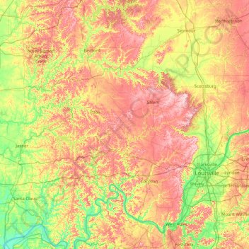
Name: Topografische Karte Hoosier National Forest, Höhe, Relief.
Ort: Hoosier National Forest, Indiana, United States of America (37.87503 -86.85119 39.10843 -86.07997)
Durchschnittliche Höhe: 192 m
Minimale Höhe: 110 m
Maximale Höhe: 310 m
Andere topografische Karten
Klicken Sie auf eine Karte, um ihre Topografie, ihre Höhe und ihr Relief anzuzeigen.
Turkey Run State Park
United States of America > Indiana > Cincinnati
Turkey Run State Park, Cox Ford Road, Cincinnati, Parke County, Indiana, 47859, United States of America
Durchschnittliche Höhe: 197 m
Maumee River
United States of America > Indiana
Maumee River, Allen County, Indiana, 46774, United States of America
Durchschnittliche Höhe: 233 m
Duck Pond
United States of America > Indiana > Muncie
Duck Pond, North McKinley Avenue, Muncie, Delaware County, Indiana, 47303, United States of America
Durchschnittliche Höhe: 289 m
Winona Lake
United States of America > Indiana > Winona Lake
Winona Lake, Kosciusko County, Indiana, 46590, United States of America
Durchschnittliche Höhe: 256 m
Saint Anthony
United States of America > Indiana > Saint Anthony
Saint Anthony, Dubois County, Indiana, 47575, United States of America
Durchschnittliche Höhe: 170 m
Shoals
United States of America > Indiana > Shoals
Shoals, Martin County, Indiana, 47581, United States of America
Durchschnittliche Höhe: 152 m
Rochester
United States of America > Indiana > Rochester
Rochester, Fulton County, Indiana, United States of America
Durchschnittliche Höhe: 240 m
Covington Dells
United States of America > Indiana > Fort Wayne > Covington Dells
Covington Dells, Fort Wayne, Allen County, Indiana, 46804, United States of America
Durchschnittliche Höhe: 252 m
River Ridge
United States of America > Indiana > River Ridge
River Ridge, Clark County, Indiana, United States of America
Durchschnittliche Höhe: 157 m
Westmoor
United States of America > Indiana > Fort Wayne > Westmoor
Westmoor, Fort Wayne, Allen County, Indiana, 46804, United States of America
Durchschnittliche Höhe: 245 m
West Franklin
United States of America > Indiana > West Franklin
West Franklin, Posey County, Indiana, United States of America
Durchschnittliche Höhe: 116 m
Center
United States of America > Indiana > Greene > Center
Center, Greene, Jay County, Indiana, United States of America
Durchschnittliche Höhe: 271 m