
Topografische Karte East Kilbride
Interaktive Karte
Klicken Sie auf die Karte, um die Höhe anzuzeigen.
Über diese Karte
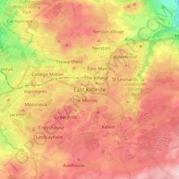
Name: Topografische Karte East Kilbride, Höhe, Relief.
Durchschnittliche Höhe: 174 m
Minimale Höhe: 46 m
Maximale Höhe: 258 m
The earliest known evidence of occupation in the area dates as far back as the late Neolithic and Early Bronze Age, as archaeological investigation has demonstrated that burial cairns in the district began as ceremonial or ritual sites of burial during the Neolithic, with the use of cup-marked, and other inscribed stones at key elevated sites, only to be later built upon with earth and re-used for burial into the Bronze Age. These findings have found further support through ongoing research indicating that many East Kilbride Cairns first noticed by the Reverend David Ure in his History of Rutherglen and East Kilbride (1793), are embedded, alongside other monuments, into a ritual landscape related to ancestor cults and relationships with key topographical features and annual solar events. A flint arrow head was discovered by Allan Forrest, a then child resident whilst groundworks were taking place in his family's garden at Glen Bervie, St Leonards in 1970 which later was identified as dating to 1500 BC (Bronze Age). Ancient graves have also been found near the Kype Water to the south of the town near Strathaven, and Roman coins, lamps, and footwear have also been found in the area.
Andere topografische Karten
Klicken Sie auf eine Karte, um ihre Topografie, ihre Höhe und ihr Relief anzuzeigen.
Blantyre
United Kingdom > Scotland > South Lanarkshire
Blantyre, South Lanarkshire, Scotland, G72 9AA, United Kingdom
Durchschnittliche Höhe: 84 m
Cambuslang
United Kingdom > Scotland > South Lanarkshire
Cambuslang, South Lanarkshire, Scotland, G72 7EL, United Kingdom
Durchschnittliche Höhe: 70 m
Douglas
United Kingdom > Scotland > South Lanarkshire
Douglas, South Lanarkshire, Scotland, ML11 0QW, United Kingdom
Durchschnittliche Höhe: 256 m
Black Mount
United Kingdom > Scotland > South Lanarkshire
Black Mount, South Lanarkshire, Scotland, ML11 8NQ, United Kingdom
Durchschnittliche Höhe: 337 m
Nerston Village
United Kingdom > Scotland > South Lanarkshire > Nerston Village
Nerston Village, South Lanarkshire, Scotland, G74 4PA, United Kingdom
Durchschnittliche Höhe: 157 m
Stonehouse
United Kingdom > Scotland > South Lanarkshire > Stonehouse
Stonehouse, South Lanarkshire, Scotland, ML9 3LG, United Kingdom
Durchschnittliche Höhe: 166 m
Lanark
United Kingdom > Scotland > South Lanarkshire > Lanark
Lanark, South Lanarkshire, Scotland, ML11, United Kingdom
Durchschnittliche Höhe: 206 m
Pinnacle
United Kingdom > Scotland > South Lanarkshire
Pinnacle, South Lanarkshire, Scotland, ML12 6UD, United Kingdom
Durchschnittliche Höhe: 441 m
Rome
United Kingdom > Scotland > South Lanarkshire
Rome, South Lanarkshire, Scotland, ML12 6UD, United Kingdom
Durchschnittliche Höhe: 408 m