
Topografische Karte Lafayette
Interaktive Karte
Klicken Sie auf die Karte, um die Höhe anzuzeigen.
Über diese Karte
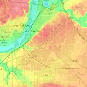
Name: Topografische Karte Lafayette, Höhe, Relief.
Ort: Lafayette, Tippecanoe County, Indiana, United States (40.35549 -86.92611 40.45305 -86.79032)
Durchschnittliche Höhe: 193 m
Minimale Höhe: 152 m
Maximale Höhe: 224 m
Lafayette is located at 40°24′38″N 86°52′29″W / 40.410585°N 86.874681°W / 40.410585; -86.874681 (40.410585, −86.874681) and is located in Fairfield and Wea Townships. Elevation at the court house is 550 feet (168 m), but city elevations range from a little over 500 feet (150 m) at the Wabash River to approximately 700 feet (210 m) in the areas of Murdock Park and Columbian Park.
Andere topografische Karten
Klicken Sie auf eine Karte, um ihre Topografie, ihre Höhe und ihr Relief anzuzeigen.
West Lafayette
United States > Indiana > Tippecanoe County
West Lafayette, Tippecanoe County, Indiana, United States
Durchschnittliche Höhe: 192 m
Burnett's Creek
United States > Indiana > Tippecanoe County > Battle Ground
Burnett's Creek, Battle Ground, Tippecanoe County, Indiana, United States
Durchschnittliche Höhe: 179 m
Battle Ground
United States > Indiana > Tippecanoe County
Battle Ground, Tippecanoe County, Indiana, United States
Durchschnittliche Höhe: 180 m
Altamont Switch
United States > Indiana > Tippecanoe County > Lafayette
Altamont Switch, Lafayette, Tippecanoe County, Indiana, 47909, United States
Durchschnittliche Höhe: 197 m
Buck Creek
United States > Indiana > Tippecanoe County
Buck Creek, Tippecanoe County, Indiana, 47924, United States
Durchschnittliche Höhe: 202 m
West Point
United States > Indiana > Tippecanoe County
West Point, Tippecanoe County, Indiana, 47992, United States
Durchschnittliche Höhe: 198 m