
Topografische Karte Grand Staircase-Escalante National Monument
Interaktive Karte
Klicken Sie auf die Karte, um die Höhe anzuzeigen.
Über diese Karte
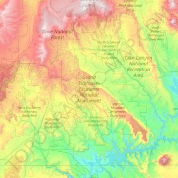
Name: Topografische Karte Grand Staircase-Escalante National Monument, Höhe, Relief.
Durchschnittliche Höhe: 1.857 m
Minimale Höhe: 1.103 m
Maximale Höhe: 3.443 m
Andere topografische Karten
Klicken Sie auf eine Karte, um ihre Topografie, ihre Höhe und ihr Relief anzuzeigen.
Antelope Island State Park
Antelope Island State Park, Antelope Island Road, Davis County, Utah, USA
Durchschnittliche Höhe: 1.314 m
Glen Canyon National Recreation Area
Glen Canyon National Recreation Area, Moody Creek Road, Garfield County, Utah, USA
Durchschnittliche Höhe: 1.798 m
La Sal Mountains Viewpoint
La Sal Mountains Viewpoint, Arches Entrance Road, Grand County, Utah, 84532-2134, USA
Durchschnittliche Höhe: 1.347 m
Timpanogos Glacier
USA > Utah > Aspen Grove
Timpanogos Glacier, Mount Timpanogos Trail #052, Aspen Grove, Utah County, Utah, USA
Durchschnittliche Höhe: 3.148 m
Fishlake National Forest
Fishlake National Forest, US Forest Service Road 1782, Garfield County, Utah, USA
Durchschnittliche Höhe: 2.075 m
Lake Fork River
Lake Fork River, Duchesne County, Utah, 84001, USA
Durchschnittliche Höhe: 1.992 m