
Topografische Karte Saint-Georges
Interaktive Karte
Klicken Sie auf die Karte, um die Höhe anzuzeigen.
Über diese Karte
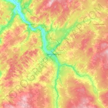
Name: Topografische Karte Saint-Georges, Höhe, Relief.
Durchschnittliche Höhe: 308 m
Minimale Höhe: 140 m
Maximale Höhe: 472 m
Andere topografische Karten
Klicken Sie auf eine Karte, um ihre Topografie, ihre Höhe und ihr Relief anzuzeigen.
Lac Wilson
Canada > Québec > Beauce-Sartigan > Saint-Théophile
Lac Wilson, Saint-Théophile, Beauce-Sartigan, Chaudière-Appalaches, Québec, Canada
Durchschnittliche Höhe: 510 m
Beauce
Canada > Québec > Beauce-Sartigan
Beauce, Beauce-Sartigan, Chaudière-Appalaches, Québec, Canada
Durchschnittliche Höhe: 377 m
Notre-Dame-des-Pins
Canada > Québec > Beauce-Sartigan
Notre-Dame-des-Pins, Beauce-Sartigan, Chaudière-Appalaches, Québec, Canada
Durchschnittliche Höhe: 242 m
Saint-Gédéon-de-Beauce
Canada > Québec > Beauce-Sartigan
Saint-Gédéon-de-Beauce, Beauce-Sartigan, Chaudière-Appalaches, Québec, G0M 1T0, Canada
Durchschnittliche Höhe: 374 m
Saint-Honoré-de-Shenley
Canada > Québec > Beauce-Sartigan
Saint-Honoré-de-Shenley, Beauce-Sartigan, Chaudière-Appalaches, Québec, G0M 1V0, Canada
Durchschnittliche Höhe: 377 m
Saint-Évariste
Canada > Québec > Beauce-Sartigan > La Guadeloupe
Saint-Évariste, La Guadeloupe, Beauce-Sartigan, Chaudière-Appalaches, Québec, G0M 1G0, Canada
Durchschnittliche Höhe: 324 m
Saint-Éphrem-de-Beauce
Canada > Québec > Beauce-Sartigan
Saint-Éphrem-de-Beauce, Beauce-Sartigan, Chaudière-Appalaches, Québec, G0M 1R0, Canada
Durchschnittliche Höhe: 315 m
Saint-René
Canada > Québec > Beauce-Sartigan
Saint-René, Beauce-Sartigan, Chaudière-Appalaches, Québec, Canada
Durchschnittliche Höhe: 320 m
Saint-Benoît-Labre
Canada > Québec > Beauce-Sartigan
Saint-Benoît-Labre, Beauce-Sartigan, Chaudière-Appalaches, Québec, Canada
Durchschnittliche Höhe: 317 m
La Guadeloupe
Canada > Québec > Beauce-Sartigan
La Guadeloupe, Beauce-Sartigan, Chaudière-Appalaches, Québec, G0M 1G0, Canada
Durchschnittliche Höhe: 329 m
Lac des Cygnes
Canada > Québec > Beauce-Sartigan > Saint-Théophile
Lac des Cygnes, Saint-Théophile, Beauce-Sartigan, Chaudière-Appalaches, Québec, Canada
Durchschnittliche Höhe: 529 m
Lac à France
Canada > Québec > Beauce-Sartigan > Saint-Côme–Linière
Lac à France, Saint-Côme–Linière, Beauce-Sartigan, Chaudière-Appalaches, Québec, Canada
Durchschnittliche Höhe: 389 m
Saint-Côme–Linière
Canada > Québec > Beauce-Sartigan
Saint-Côme–Linière, Beauce-Sartigan, Chaudière-Appalaches, Québec, G0M 1J0, Canada
Durchschnittliche Höhe: 334 m
Lac-Poulin
Canada > Québec > Beauce-Sartigan
Lac-Poulin, Beauce-Sartigan, Chaudière-Appalaches, Québec, Canada
Durchschnittliche Höhe: 338 m
Saint-Évariste-de-Forsyth
Canada > Québec > Beauce-Sartigan
Saint-Évariste-de-Forsyth, Beauce-Sartigan, Chaudière-Appalaches, Québec, G0M 1S0, Canada
Durchschnittliche Höhe: 370 m
Saint-Georges
Canada > Québec > Beauce-Sartigan
Saint-Georges, Beauce-Sartigan, Chaudière-Appalaches, Québec, Canada
Durchschnittliche Höhe: 296 m
Saint-Théophile
Canada > Québec > Beauce-Sartigan
Saint-Théophile, Beauce-Sartigan, Chaudière-Appalaches, Québec, G0M 2A0, Canada
Durchschnittliche Höhe: 413 m