
Topografische Karte Edmonton
Interaktive Karte
Klicken Sie auf die Karte, um die Höhe anzuzeigen.
Über diese Karte
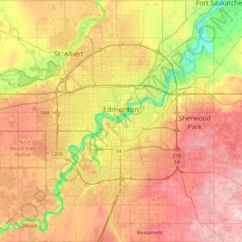
Name: Topografische Karte Edmonton, Höhe, Relief.
Ort: Edmonton, Alberta, Canada (53.33726 -113.71384 53.71626 -113.27148)
Durchschnittliche Höhe: 690 m
Minimale Höhe: 600 m
Maximale Höhe: 783 m
La ville est située près de la partie nord de la rivière Saskatchewan. les rives de la rivière, qui traverse la ville, font partie des attraits géographiques de la ville. L'altitude moyenne de Edmonton est de 645 mètres.
Andere topografische Karten
Klicken Sie auf eine Karte, um ihre Topografie, ihre Höhe und ihr Relief anzuzeigen.
Sherwood Park
Canada > Alberta > Division No. 11
Sherwood Park, Division No. 11, Alberta, Canada
Durchschnittliche Höhe: 691 m
City of Wetaskiwin
Canada > Alberta > Division No. 11
City of Wetaskiwin, Division No. 11, Alberta, Canada
Durchschnittliche Höhe: 760 m
Fort Saskachewan
Canada > Alberta > Division No. 11
Fort Saskachewan, Division No. 11, Alberta, Canada
Durchschnittliche Höhe: 637 m
City of Leduc
Canada > Alberta > Division No. 11
City of Leduc, Division No. 11, Alberta, Canada
Durchschnittliche Höhe: 727 m
Chappelle
Canada > Alberta > Division No. 11
Chappelle, Heritage Valley, Division No. 11, Alberta, Canada
Durchschnittliche Höhe: 695 m
Nisku
Canada > Alberta > Division No. 11
Nisku, Division No. 11, Alberta, T9E 0W8, Canada
Durchschnittliche Höhe: 714 m
City of Spruce Grove
Canada > Alberta > Division No. 11
City of Spruce Grove, Division No. 11, Alberta, Canada
Durchschnittliche Höhe: 699 m