
Topografische Karte Cornbury and Wychwood
Interaktive Karte
Klicken Sie auf die Karte, um die Höhe anzuzeigen.
Über diese Karte
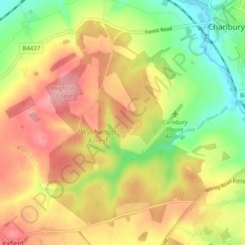
Name: Topografische Karte Cornbury and Wychwood, Höhe, Relief.
Durchschnittliche Höhe: 146 m
Minimale Höhe: 84 m
Maximale Höhe: 203 m
Andere topografische Karten
Klicken Sie auf eine Karte, um ihre Topografie, ihre Höhe und ihr Relief anzuzeigen.
West Oxfordshire
United Kingdom > England > West Oxfordshire
West Oxfordshire, Oxfordshire, South East, England, United Kingdom
Durchschnittliche Höhe: 119 m
Combe
United Kingdom > England > West Oxfordshire
Combe, West Oxfordshire, Oxfordshire, South East, England, United Kingdom
Durchschnittliche Höhe: 106 m
Elm Bank
United Kingdom > England > West Oxfordshire
Elm Bank, West Oxfordshire, Oxfordshire, South East, England, OX29 0SY, United Kingdom
Durchschnittliche Höhe: 101 m
Neat Enstone
United Kingdom > England > West Oxfordshire > Neat Enstone
Neat Enstone, West Oxfordshire, Oxfordshire, South East England, England, OX7 4NX, United Kingdom
Durchschnittliche Höhe: 159 m