
Topografische Karte Wichita
Interaktive Karte
Klicken Sie auf die Karte, um die Höhe anzuzeigen.
Über diese Karte
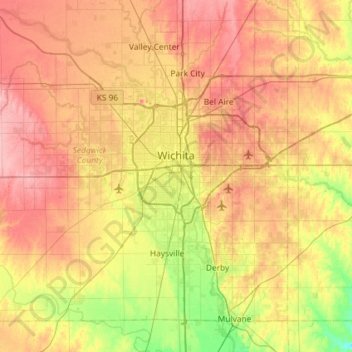
Name: Topografische Karte Wichita, Höhe, Relief.
Ort: Wichita, Sedgwick County, Kansas, United States (37.48902 -97.73435 37.84020 -97.15300)
Durchschnittliche Höhe: 408 m
Minimale Höhe: 355 m
Maximale Höhe: 459 m
The city lies on the Arkansas River near the western edge of the Flint Hills in the Wellington-McPherson Lowlands region of the Great Plains. The area's topography is characterized by the broad alluvial plain of the Arkansas River valley and the moderately rolling slopes that rise to the higher lands on either side.
Andere topografische Karten
Klicken Sie auf eine Karte, um ihre Topografie, ihre Höhe und ihr Relief anzuzeigen.
Haysville
United States > Kansas > Sedgwick County
Haysville, Sedgwick County, Kansas, United States
Durchschnittliche Höhe: 388 m
Bentley
United States > Kansas > Sedgwick County
Bentley, Sedgwick County, Kansas, United States
Durchschnittliche Höhe: 424 m
Wichita
United States > Kansas > Sedgwick County > Wichita
Wichita, Sedgwick County, Kansas, 67202, United States
Durchschnittliche Höhe: 410 m
Derby
United States > Kansas > Sedgwick County > Derby
Derby, Sedgwick County, Kansas, United States
Durchschnittliche Höhe: 392 m