
Topografische Karte Colorado
Interaktive Karte
Klicken Sie auf die Karte, um die Höhe anzuzeigen.
Über diese Karte
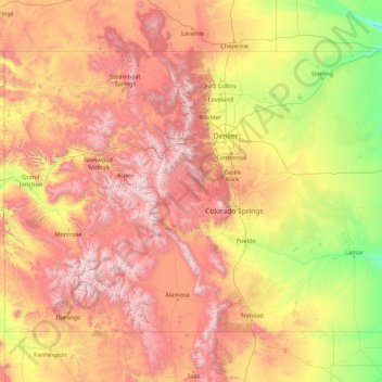
Name: Topografische Karte Colorado, Höhe, Relief.
Ort: Colorado, United States (36.99252 -109.06019 41.00340 -102.04159)
Durchschnittliche Höhe: 2.060 m
Minimale Höhe: 1.020 m
Maximale Höhe: 4.379 m
Thirty days later on February 28, 1861, outgoing U.S. President James Buchanan signed an Act of Congress organizing the free Territory of Colorado. The original boundaries of Colorado remain unchanged except for government survey amendments. The name Colorado was chosen because it was commonly believed that the Colorado River originated in the territory. In 1776, Spanish priest Silvestre Vélez de Escalante recorded that Native Americans in the area knew the river as el Rio Colorado for the red-brown silt that the river carried from the mountains. In 1859, a U.S. Army topographic expedition led by Captain John Macomb located the confluence of the Green River with the Grand River in what is now Canyonlands National Park in Utah. The Macomb party designated the confluence as the source of the Colorado River.
Andere topografische Karten
Klicken Sie auf eine Karte, um ihre Topografie, ihre Höhe und ihr Relief anzuzeigen.
Litchfield County
United States > Connecticut > Northwest Hills Planning Region
Litchfield County, Northwest Hills Planning Region, Connecticut, United States
Durchschnittliche Höhe: 252 m
Moore County
United States > North Carolina
Moore County, North Carolina, United States
Durchschnittliche Höhe: 127 m
Pinellas County
Pinellas County, Florida, United States
Durchschnittliche Höhe: 4 m
Baltimore County
Baltimore County, Maryland, United States
Durchschnittliche Höhe: 123 m
Roseville
United States > California > Placer County
Roseville, Placer County, California, United States
Durchschnittliche Höhe: 61 m
Thomas Terrace
United States > Virginia > Campbell County
Thomas Terrace, Campbell County, Virginia, United States
Durchschnittliche Höhe: 226 m
Everett
United States > Washington > Snohomish County
Everett, Snohomish County, Washington, United States
Durchschnittliche Höhe: 66 m
Wake County
United States > North Carolina
Wake County, North Carolina, United States
Durchschnittliche Höhe: 96 m
Cannondale
United States > Connecticut > Western Connecticut Planning Region > Wilton
Cannondale, Wilton, Western Connecticut Planning Region, Connecticut, 06897, United States
Durchschnittliche Höhe: 110 m
Seven Lakes
United States > North Carolina > Moore County
Seven Lakes, Moore County, North Carolina, United States
Durchschnittliche Höhe: 168 m
Beaverton
United States > Oregon > Washington County
Beaverton, Washington County, Oregon, United States
Durchschnittliche Höhe: 106 m
Largo
United States > Florida > Pinellas County
Largo, Pinellas County, Florida, United States
Durchschnittliche Höhe: 9 m
McCracken County
McCracken County, Kentucky, United States
Durchschnittliche Höhe: 119 m
Port Charlotte
United States > Florida > Charlotte County
Port Charlotte, Charlotte County, Florida, 33952, United States
Durchschnittliche Höhe: 4 m
Fargo
United States > North Dakota > Cass County
Fargo, Cass County, North Dakota, United States
Durchschnittliche Höhe: 277 m
Mount Vernon
United States > Washington > Skagit County
Mount Vernon, Skagit County, Washington, 98273, United States
Durchschnittliche Höhe: 37 m
Ocean County
Ocean County, New Jersey, United States
Durchschnittliche Höhe: 15 m
Redwood City
United States > California > San Mateo County
Redwood City, San Mateo County, California, United States
Durchschnittliche Höhe: 32 m
Puyallup
United States > Washington > Pierce County
Puyallup, Pierce County, Washington, United States
Durchschnittliche Höhe: 66 m
Bridge Creek
United States > Oklahoma > Grady County
Bridge Creek, Grady County, Oklahoma, United States
Durchschnittliche Höhe: 411 m
Arbuckle
United States > California > Colusa County
Arbuckle, Colusa County, California, 95912, United States
Durchschnittliche Höhe: 42 m
Oceanview
United States > South Carolina > Charleston County
Oceanview, Charleston County, South Carolina, 29412, United States
Durchschnittliche Höhe: 2 m
Buckingham
United States > Florida > Lee County > Buckingham
Buckingham, Lee County, Florida, 33905, United States
Durchschnittliche Höhe: 7 m
Leavenworth County
Leavenworth County, Kansas, United States
Durchschnittliche Höhe: 290 m
Ophir
United States > Utah > Tooele County
Ophir, Tooele County, Utah, United States
Durchschnittliche Höhe: 2.232 m
Lynnwood
United States > Washington > Snohomish County
Lynnwood, Snohomish County, Washington, 98037, United States
Durchschnittliche Höhe: 121 m
Santa Ana Pueblo
United States > New Mexico > Sandoval County
Santa Ana Pueblo, Sandoval County, New Mexico, United States
Durchschnittliche Höhe: 1.576 m
Hennepin County
Hennepin County, Minnesota, United States
Durchschnittliche Höhe: 280 m
Lake Forest
United States > California > Orange County
Lake Forest, Orange County, California, United States
Durchschnittliche Höhe: 193 m
San Antonio
United States > Texas > Bexar County
San Antonio, Bexar County, Texas, United States
Durchschnittliche Höhe: 247 m
Rudeston
United States > New York > Hamilton County
Rudeston, Town of Arietta, Hamilton County, New York, United States
Durchschnittliche Höhe: 533 m
Hollis Park
United States > Arizona > Maricopa County > Tempe
Hollis Park, Tempe, Maricopa County, Arizona, United States
Durchschnittliche Höhe: 362 m
Good
United States > Virginia > Frederick County
Good, Frederick County, Virginia, 22625, United States
Durchschnittliche Höhe: 356 m
Hickory
United States > North Carolina > Catawba County
Hickory, Catawba County, North Carolina, United States
Durchschnittliche Höhe: 317 m
Shawnee County
Shawnee County, Kansas, United States
Durchschnittliche Höhe: 315 m
Starks
United States > Maine > Somerset County
Starks, Somerset County, Maine, United States
Durchschnittliche Höhe: 129 m
Little Egg Harbor
United States > New Jersey > Ocean County > Little Egg Harbor Township
Little Egg Harbor, Little Egg Harbor Township, Ocean County, New Jersey, United States
Durchschnittliche Höhe: 2 m
Park Ridge
United States > Illinois > Cook County
Park Ridge, Maine Township, Cook County, Illinois, 60068, United States
Durchschnittliche Höhe: 198 m
Crescent City
United States > California > Del Norte County
Crescent City, Del Norte County, California, United States
Durchschnittliche Höhe: 31 m
Evergreen
United States > Colorado > Jefferson County
Evergreen, Jefferson County, Colorado, 80457, United States
Durchschnittliche Höhe: 2.301 m
Whidbey Island
United States > Washington > Island County
Whidbey Island, Island County, Washington, United States
Durchschnittliche Höhe: 45 m
Bennet Park
United States > Michigan > Eaton County > Charlotte
Bennet Park, Charlotte, Eaton Township, Eaton County, Michigan, United States
Durchschnittliche Höhe: 277 m
Easton
United States > Massachusetts > Bristol County
Easton, Bristol County, Massachusetts, United States
Durchschnittliche Höhe: 47 m
Lake Of The Ozarks
United States > Missouri > Camden County > Osage Beach
Lake Of The Ozarks, Osage Beach, Camden County, Missouri, 65079, United States
Durchschnittliche Höhe: 265 m
Tampa
United States > Florida > Hillsborough County
Tampa, Hillsborough County, Florida, United States
Durchschnittliche Höhe: 11 m
Newtown
United States > Connecticut > Western Connecticut Planning Region
Newtown, Western Connecticut Planning Region, Connecticut, United States
Durchschnittliche Höhe: 147 m
Freeburn
United States > Kentucky > Pike County
Freeburn, Pike County, Kentucky, 41528, United States
Durchschnittliche Höhe: 342 m
Mount Ida
United States > Arkansas > Montgomery County
Mount Ida, Montgomery County, Arkansas, United States
Durchschnittliche Höhe: 215 m