
Topografische Karte Savannah
Interaktive Karte
Klicken Sie auf die Karte, um die Höhe anzuzeigen.
Über diese Karte
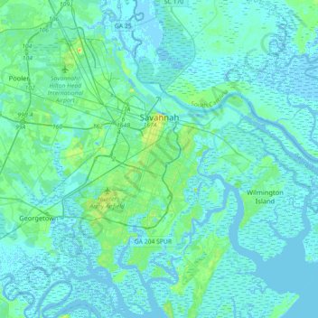
Name: Topografische Karte Savannah, Höhe, Relief.
Ort: Savannah, Chatham County, Georgia, United States (31.88785 -81.37143 32.18966 -81.02952)
Durchschnittliche Höhe: 4 m
Minimale Höhe: -5 m
Maximale Höhe: 33 m
Savannah is prone to flooding, due to abundant rainfall, an elevation at just above sea level, and the shape of the coastline, which poses a greater surge risk during hurricanes. The city currently uses five canals. In addition, several pumping stations have been built to help reduce the effects of flash flooding.
Andere topografische Karten
Klicken Sie auf eine Karte, um ihre Topografie, ihre Höhe und ihr Relief anzuzeigen.
Oakdale
United States > Georgia > Chatham County > Savannah
Oakdale, Savannah, Chatham County, Georgia, 31406, United States
Durchschnittliche Höhe: 10 m
Thunderbolt
United States > Georgia > Chatham County
Thunderbolt, Chatham County, Georgia, United States
Durchschnittliche Höhe: 5 m
Welwood
United States > Georgia > Chatham County > Savannah
Welwood, Savannah, Chatham County, Georgia, 31409, United States
Durchschnittliche Höhe: 7 m
Tybee Island
United States > Georgia > Chatham County
Tybee Island, Chatham County, Georgia, 31328, United States
Durchschnittliche Höhe: 1 m
O'Leary
United States > Georgia > Chatham County > Port Wentworth > O'Leary
O'Leary, Port Wentworth, Chatham County, Georgia, 31407, United States
Durchschnittliche Höhe: 5 m