
Topografische Karte Grenagh
Interaktive Karte
Klicken Sie auf die Karte, um die Höhe anzuzeigen.
Über diese Karte
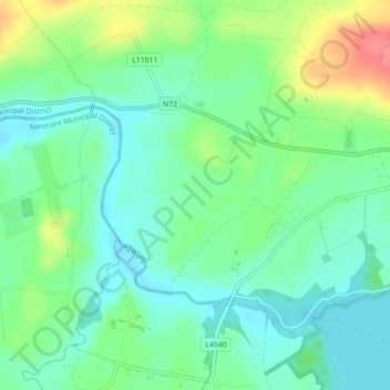
Name: Topografische Karte Grenagh, Höhe, Relief.
Durchschnittliche Höhe: 36 m
Minimale Höhe: 14 m
Maximale Höhe: 81 m
Andere topografische Karten
Klicken Sie auf eine Karte, um ihre Topografie, ihre Höhe und ihr Relief anzuzeigen.
Shronowen
Shronowen, Shronowen ED, Listowel Municipal District, County Kerry, Munster, Ireland
Durchschnittliche Höhe: 27 m
Torc Mountain
Torc Mountain, Killarney Municipal District, County Kerry, Munster, V93 RR59, Ireland
Durchschnittliche Höhe: 202 m
Lisselton
Lisselton, Listowel Municipal District, County Kerry, Munster, Ireland
Durchschnittliche Höhe: 34 m
Farranfore
Farranfore, Tralee Municipal District, County Kerry, Munster, V93 YP44, Ireland
Durchschnittliche Höhe: 59 m
Stradbally Mountain
Stradbally Mountain, Kenmare Municipal District, County Kerry, Munster, Ireland
Durchschnittliche Höhe: 487 m
Glencar
Glencar, Kenmare Municipal District, County Kerry, Munster, Ireland
Durchschnittliche Höhe: 114 m
Cahersiveen
Cahersiveen, County Kerry, Munster, V23 FF95, Ireland
Durchschnittliche Höhe: 66 m
Kilgarvan
Kilgarvan, Kilgarvan ED, Kenmare Municipal District, County Kerry, Munster, Ireland
Durchschnittliche Höhe: 71 m
Brosna
Brosna, Tralee Municipal District, County Kerry, Munster, Ireland
Durchschnittliche Höhe: 163 m
Killarney
Killarney, Killarney Municipal District, County Kerry, Munster, Ireland
Durchschnittliche Höhe: 57 m
Rathmore
Rathmore, Rathmore ED, Killarney Municipal District, County Kerry, Munster, P51 PT66, Ireland
Durchschnittliche Höhe: 149 m
Lispole
Lispole, Kenmare Municipal District, County Kerry, Munster, V92 DN23, Ireland
Durchschnittliche Höhe: 107 m
Kilcummin
Kilcummin, Kilcummin ED, Killarney Municipal District, County Kerry, Munster, Ireland
Durchschnittliche Höhe: 142 m
Cromane Upper
Cromane Upper, Killorglin ED, Kenmare Municipal District, County Kerry, Munster, Ireland
Durchschnittliche Höhe: 18 m
Killorglin
Killorglin, Killorglin ED, Kenmare Municipal District, County Kerry, Munster, Ireland
Durchschnittliche Höhe: 23 m
Lyreboy
Lyreboy, Maum ED, Kenmare Municipal District, County Kerry, Munster, Ireland
Durchschnittliche Höhe: 342 m
Killarney
Killarney, Killarney Urban ED, Killarney Municipal District, County Kerry, Munster, Ireland
Durchschnittliche Höhe: 39 m
Glenmore
Glenmore, Glanmore ED, Kenmare Municipal District, County Kerry, Munster, Ireland
Durchschnittliche Höhe: 269 m
Glanmore
Glanmore, Kilgobban ED, Kenmare Municipal District, County Kerry, Munster, Ireland
Durchschnittliche Höhe: 187 m
Beheenagh
Beheenagh, Kilgobban ED, Kenmare Municipal District, County Kerry, Munster, Ireland
Durchschnittliche Höhe: 347 m
Banna Strand
Banna Strand, Banna ED, Tralee Municipal District, County Kerry, Munster, Ireland
Durchschnittliche Höhe: 4 m
Lauragh
Lauragh, Kenmare Municipal District, County Kerry, Munster, Ireland
Durchschnittliche Höhe: 89 m
Killarney
Ireland > County Kerry > Killarney
Killarney, Killarney Municipal District, County Kerry, Munster, V93 AYP9, Ireland
Durchschnittliche Höhe: 66 m
Glashanacree
Glashanacree, Kilshenane ED, Tralee Municipal District, County Kerry, Munster, Ireland
Durchschnittliche Höhe: 143 m
Derrybanane
Derrybanane, Flesk ED, Killarney Municipal District, County Kerry, Munster, Ireland
Durchschnittliche Höhe: 299 m
Valencia Island
Valencia Island, Kenmare Municipal District, County Kerry, Munster, Ireland
Durchschnittliche Höhe: 39 m
Barrow
Barrow, Ballynahaglish ED, Tralee Municipal District, County Kerry, Munster, Ireland
Durchschnittliche Höhe: 7 m
Lough Guitane
Lough Guitane, Flesk ED, Killarney Municipal District, County Kerry, Munster, Ireland
Durchschnittliche Höhe: 112 m
Knoppoge
Knoppoge, Ballyduff ED, Listowel Municipal District, County Kerry, Munster, Ireland
Durchschnittliche Höhe: 29 m
Gunsborough
Gunsborough, Gunsborough ED, Listowel Municipal District, County Kerry, Munster, V31 TR74, Ireland
Durchschnittliche Höhe: 54 m
Barraduff
Ireland > County Kerry > Barraduff
Barraduff, Killarney Municipal District, County Kerry, Munster, Ireland
Durchschnittliche Höhe: 124 m
Knocknacree
Knocknacree, Ballyduff ED, Listowel Municipal District, County Kerry, Munster, Ireland
Durchschnittliche Höhe: 51 m
Pallis
Pallis, Lahard ED, Killarney Municipal District, County Kerry, Munster, Ireland
Durchschnittliche Höhe: 48 m
Ballincolla
Ballincolla, Dunurlin ED, Kenmare Municipal District, County Kerry, Munster, Ireland
Durchschnittliche Höhe: 22 m
Rattoo Round Tower
Rattoo Round Tower, R551, Ballyduff ED, Listowel Municipal District, County Kerry, Munster, Ireland
Durchschnittliche Höhe: 16 m
Knockbrack
Knockbrack, Ballynorig ED, Listowel Municipal District, County Kerry, Munster, Ireland
Durchschnittliche Höhe: 20 m
Heirhill
Heirhill, Ballyheige ED, Listowel Municipal District, County Kerry, Munster, Ireland
Durchschnittliche Höhe: 54 m
Raheens
Raheens, Bahaghs ED, Kenmare Municipal District, County Kerry, Munster, Ireland
Durchschnittliche Höhe: 166 m
Ballintobernig
Ballintobernig, Ratass ED, Tralee Municipal District, County Kerry, Munster, Ireland
Durchschnittliche Höhe: 182 m
Castlelough
Castlelough, Muckross ED, Killarney Municipal District, County Kerry, Munster, V93 RR59, Ireland
Durchschnittliche Höhe: 35 m
Drombeg
Drombeg, Shronowen ED, Listowel Municipal District, County Kerry, Munster, Ireland
Durchschnittliche Höhe: 43 m
Knockglass Beg
Knockglass Beg, Knockglass ED, Kenmare Municipal District, County Kerry, Munster, Ireland
Durchschnittliche Höhe: 94 m
Ballydunlea
Ballydunlea, Tralee Rural ED, Tralee Municipal District, County Kerry, Munster, Ireland
Durchschnittliche Höhe: 158 m
Ballyconnell
Ballyconnell, Kilfeighny ED, Listowel Municipal District, County Kerry, Munster, Ireland
Durchschnittliche Höhe: 41 m
Coolroe Upper
Coolroe Upper, Glanbehy ED, Kenmare Municipal District, County Kerry, Munster, Ireland
Durchschnittliche Höhe: 178 m
Cahernageeha
Cahernageeha, Darrynane ED, Kenmare Municipal District, County Kerry, Munster, Ireland
Durchschnittliche Höhe: 223 m