
Topografische Karte Novi Sad
Interaktive Karte
Klicken Sie auf die Karte, um die Höhe anzuzeigen.
Über diese Karte
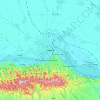
Name: Topografische Karte Novi Sad, Höhe, Relief.
Durchschnittliche Höhe: 135 m
Minimale Höhe: 68 m
Maximale Höhe: 538 m
The city lies on the meander of the river Danube, which is only 350 meters wide beneath the marking stones of Petrovaradin. A section of the Danube-Tisza-Danube Canal marks the northern edge of the wider city centre. The main part of the city lies on the left bank of the Danube in the region of Bačka, while the smaller settlements of Petrovaradin and Sremska Kamenica lie on the right bank, in the region of Srem (Syrmia). The section situated on the left bank of the river lies on one of the southernmost and lowest parts of the Pannonian Plain, while Fruška Gora on the right bank is a horst mountain. Alluvial plains along the Danube are well-formed, especially on the left bank, and in some parts 10 kilometres (6 miles) from the river. A large part of Novi Sad lies on a fluvial terrace with an elevation between 80 to 83 metres (262 to 272 feet). The northern part of Fruška Gora is composed of massive landslide zones, although they are largely inactive with the exception of the Ribnjak neighbourhood between Sremska Kamenica and Petrovaradin Fortress. The total land area of the city is 699 square kilometres (270 sq mi), while its urban area spans 129.7 km2 (50 sq mi).