
Topografische Karte Hull
Interaktive Karte
Klicken Sie auf die Karte, um die Höhe anzuzeigen.
Über diese Karte
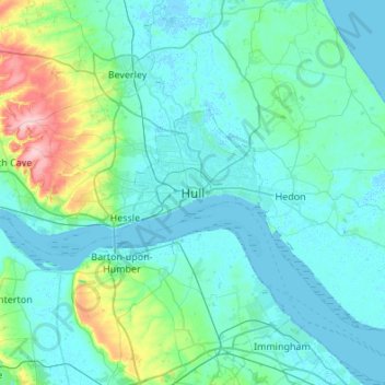
Name: Topografische Karte Hull, Höhe, Relief.
Ort: Hull, Kingston upon Hull, England, HU1 3RJ, United Kingdom (53.58357 -0.49948 53.90357 -0.17948)
Durchschnittliche Höhe: 21 m
Minimale Höhe: -4 m
Maximale Höhe: 168 m
Kingston upon Hull is on the northern bank of the Humber Estuary. The city centre is west of the River Hull and close to the Humber. The city is built upon alluvial and glacial deposits which overlie chalk rocks but the underlying chalk has no influence on the topography. The land within the city is generally very flat and is only 2 to 4 metres (6.5 to 13 ft) above sea level. Because of the relative flatness of the site there are few physical constraints upon building and many open areas are the subject of pressures to build.
Andere topografische Karten
Klicken Sie auf eine Karte, um ihre Topografie, ihre Höhe und ihr Relief anzuzeigen.
Sutton
United Kingdom > England > Kingston upon Hull > Sutton
Sutton, Kingston upon Hull, Yorkshire and the Humber, England, HU7 4UF, United Kingdom
Durchschnittliche Höhe: 3 m